Protected Landscape of Barreiro da Faneca
| Protected Landscape of Barreiro da Faneca (Área de Paisagem Protegida do Barreiro da Faneca) | |
| Barreio da Faneca, Faneca | |
| Área de Paisagem Protegida | |
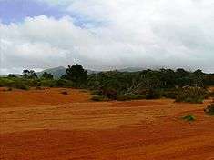 A view of the "painted desert" of Barreiro da Faneca
 Barreiro da Faneca Barreiro da Faneca (Santa Maria, Azores) | |
| Official name: Área de Paisagem Protegida do Barreiro da Faneca | |
| Nickname: Faneca | |
| Country | |
|---|---|
| Autonomous Region | |
| Group | Central |
| Island | Santa Maria |
| Municipality | Vila do Porto |
| Location | Santa Maria |
| - elevation | 200 m (656 ft) |
| - coordinates | 36°59′56.99″N 25°7′22.55″W / 36.9991639°N 25.1229306°WCoordinates: 36°59′56.99″N 25°7′22.55″W / 36.9991639°N 25.1229306°W |
| Lowest point | Sea level |
| - location | Atlantic Ocean |
| Biomes | Temperate, Mediterranean |
| Geology | Alkali basalt, Tephra, Trachyte, Trachybasalt |
| Orogeny | Volcanism |
| Period | Holocene |
| Founded | Decreto Legislativo Regional 46/2008/A |
| Date | 7 November 2008 |
| Management | Secretário Regional do Ambiente e do Mar |
| - location | Rua Cônsul Dabney - Colónia Alemã, 140, Horta, Faial |
| - elevation | 28 m (92 ft) |
| - coordinates | 38°32′2″N 28°37′45″W / 38.53389°N 28.62917°W |
| Owner | Regional Government of the Azores |
| For public | Public |
| Easiest access | Multiple |
| IUCN category | V Protected Landscape/Seascape |
| Wikimedia Commons: Barreiro da Faneca | |
The Protected Landscape of Barreiro da Faneca (Portuguese: Área de Paisagem Protegida do Barreiro da Faneca) is a geological region and protected landscape in the civil parish of São Pedro, in the municipality of Vila do Porto, on the Portuguese island of Santa Maria, archipelago of the Azores.
History
The Barreiro da Faneca was integrated into the Área de Paisagem Protegida do Barreiro da Faneca (Protected Landscape of Barreiro da Faneca) with the promulgation of Regional Decree 47/2008/A (7 November 2008), administered by the Secretário Regional do Ambiente e do Mar (Regional Secretariat of the Environment and the Sea).[1]
Geography
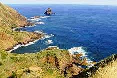
The Protected Landscape of Barreiro da Faneca extends from Ponta dos Frades until the northern cliff of the island, and includes not only Barreiro da Faneca and the bays of Raposo, Cré and Tagarete; the protected area includes a superficie of approximately 1542 hectares.[2] Contiguous to the protected area is the Bay of Cré, known for the accumulation of sediments, such as limestone and fossilized conglomerates, with visible marine fossils. The Bay of Raposo, nearby is known for its cliffs, waterfall and river mouth, while the Bay of Tagarete is also known for deposits of marine fossils.
Physical geography
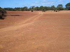
Barreiro da Fancea is a superficial area of arid and clay terrain, built up from the geological area known as Formação de Feteiras (Feteiras Formation), that corresponds to the most recent volcanism that was essentially explosive, and constituted of pyroclastic materials.[2] Later, these projectiles and deposits were altered in reddish clays due to the warm and humid climate, resulting in an area of semi-desert-like geology composed of yellowish-red sands.[2]
The location is situated at 200 metres (660 ft) above sea level and includes a hummocky surface, with gentle slopes of 4-5% incline and a limited drainage capability.[2] The areas with limited or lacking vegetation the soils are susceptible to erosion, resulting in the formation of dunes caused by hydrological or wind-based erosion.[2] These conditions have resulted in a landscape that is completely unique to Santa Maria in the archipelago, resulting in it becoming named the Deserto Vermelho dos Açores (Red Desert of the Azores).[2]
Biome
At the same time, there has been encroachment of vegetation in 70% of the area, including the spontaneous blooming of endemic species, such as Heather (Erica azorica), White wood (Picconia azorica), Globe daisy shrub(Scabiosa nitens), Spurge (Euphorbia azorica), and other species of important Laurel and Faia-da-terra.[2]
The group of bays are limited by large cliffs with extreme slopes, with altitudes ranging from 50 to 150 metres (160 to 490 ft) above sea level, and are recognized for their ecological importance and distinct landscapes, that include the islet of Lagoinhas, known for support of marine bird habits. Populations of migratory and marine birds like Shearwaters (Calonectris diomedea borealis), Garajau-comum (Sterna hirundo) and Garajau-rosado (Sterna dougallii).
References
Notes
Sources
- GRA, ed. (7 November 2008), Decreto Legislativo Regional 47/2008/A: Parque Natural da Ilha de Santa Maria (PDF) (in Portuguese) (217) (Série 1 ed.), Lisbon, Portugal: Diário da República, pp. 7787–7801, retrieved 20 April 2014
- Silva, José Guedes (2002), O Barreiro da Faneca (in Portuguese), Vila do Porto (Azores), Portugal: Câmara Municipal de Vila do Porto, ISBN 972-96168-7-6
- SRA, ed. (2014), Paisagem Protegida de Interesse Regional: Barreiro da Faneca e Costa Norte (in Portuguese), Horta (Azores), Portugal: Secretária Regional do Ambiente