Bardera
| Bardera بااردىرآ Baardheere | |
|---|---|
| contain 7 | |
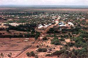 View over Bardera | |
| Nickname(s): baladka raaxada | |
 Bardera بااردىرآ Location in Somalia | |
| Coordinates: 2°20′N 42°17′E / 2.333°N 42.283°E | |
| Country |
|
| State | Jubaland |
| Region | Gedo |
| District | District |
| Government | |
| • Bardera District Commissioner | Cadow Nuur Xasan |
| Population [1] | |
| • Estimate (2011) | 100,000 - 150,000 |
| Time zone | UTC+3 (EAT) |
Bardera City (Arabic: بااردىرآ, Somali: Baardheere) is an important agricultural city in the Gedo region of Somalia. It is the second most populous town in the Juba Valley, with Kismayo being the largest and most densely populated city in the region, Garbahaarreey serving as Gedo's capital. Bardhere is mainly inhabited by the Mareehan clan (Sade confederation).
The name Baardheere is a compound of two words: Baar meaning "palm tree", and dheere meaning "tall", a reference to the ubiquitous palm trees in the area. The city is also reputed as a hub of Islamic scholarship and agricultural production.
History
During the Middle Ages, Bardera and its surrounding area was part of the Ajuran Empire that governed much of southern Somalia and eastern Ethiopia, with its domain extending from Hobyo in the north, to Qelafo in the west, to Kismayo in the south.[2]
In the early modern period, Bardera was ruled by the Geledi Sultanate. The kingdom was eventually incorporated into Italian Somaliland protectorate in 1910 after the death of the last Sultan Osman Ahmed.[3] After independence in 1960, the city was made the center of the official Bardera District.
Overview
Bardera is situated 2-3 degrees latitude north of the equator and at a longitude of 42-43 degrees. It is characterized by warm weather and high humidity. The climate is ideally suited for year-round crop production.
In the 1930s, there were about 8,000 inhabitants in the city.
Agriculture
Large numbers of Bardera's residents make their living working in the many small and large farms on the span of the Jubb River in Bardera District. Agricultural products from Bardera farms are sold throughout the country. Sorghum, corn or maize, different types of onions, beans, sesame, tobacco, and fruits such as bananas, watermelon, oranges, papayas, and mangoes, from Bardera farms reach markets as far as Djibouti, about 3,000 km away to the north of Somalia.

There are two types of farming which exist in Bardera area: Irrigated farming and seasonal farming. Many medium- and small-scale farms near the river use water pumping machines. These motors irrigate the land with canals, and farmers plant crops. The majority of farmers use a low-tech farming method of farming during the two rainy seasons of gu' and deyr. Small operation farms are found throughout Gedo region, far away from the river banks where families plant sorghum, maize, and beans on any land that is suitable for farming. These farming plots are located on sandy soft earth often with muddy combinations. The locals call this type of earth adable.
Mogadishu's fruit and vegetable market used to have a section containing Bardera's famous onion product. Since the start of the civil war in Somalia, produce from Bardera to large cities like Mogadishu, Kismayo, or Baidoa were diverted to Kenyan markets such as Wajir, Garissa, Mombasa, and Nairobi.
Palmtree being part of the name Bardera, there are many beautiful palm trees along the river bank and almost every farm has one or two palm trees.
Climate
| Climate data for Bardera | |||||||||||||
|---|---|---|---|---|---|---|---|---|---|---|---|---|---|
| Month | Jan | Feb | Mar | Apr | May | Jun | Jul | Aug | Sep | Oct | Nov | Dec | Year |
| Record high °C (°F) | 45.0 (113) |
45.0 (113) |
49.0 (120.2) |
46.0 (114.8) |
45.0 (113) |
46.0 (114.8) |
42.0 (107.6) |
39.0 (102.2) |
43.0 (109.4) |
44.0 (111.2) |
43.0 (109.4) |
43.0 (109.4) |
49.0 (120.2) |
| Average high °C (°F) | 38.2 (100.8) |
39.3 (102.7) |
41.4 (106.5) |
38.0 (100.4) |
35.6 (96.1) |
34.0 (93.2) |
32.5 (90.5) |
33.1 (91.6) |
34.9 (94.8) |
36.1 (97) |
35.9 (96.6) |
36.7 (98.1) |
36.3 (97.3) |
| Daily mean °C (°F) | 29.7 (85.5) |
30.6 (87.1) |
31.5 (88.7) |
30.4 (86.7) |
29.0 (84.2) |
27.7 (81.9) |
26.2 (79.2) |
26.8 (80.2) |
28.2 (82.8) |
29.1 (84.4) |
28.8 (83.8) |
29.1 (84.4) |
29.0 (84.2) |
| Average low °C (°F) | 21.4 (70.5) |
22.0 (71.6) |
22.9 (73.2) |
22.9 (73.2) |
22.6 (72.7) |
21.3 (70.3) |
20.4 (68.7) |
20.9 (69.6) |
21.5 (70.7) |
22.1 (71.8) |
21.7 (71.1) |
21.6 (70.9) |
21.8 (71.2) |
| Record low °C (°F) | 16.0 (60.8) |
17.0 (62.6) |
18.0 (64.4) |
18.0 (64.4) |
18.0 (64.4) |
16.5 (61.7) |
15.0 (59) |
12.0 (53.6) |
16.0 (60.8) |
18.5 (65.3) |
14.0 (57.2) |
16.0 (60.8) |
12.0 (53.6) |
| Average precipitation mm (inches) | 6 (0.24) |
6 (0.24) |
22 (0.87) |
93 (3.66) |
55 (2.17) |
15 (0.59) |
25 (0.98) |
7 (0.28) |
6 (0.24) |
63 (2.48) |
57 (2.24) |
29 (1.14) |
384 (15.12) |
| Average precipitation days (≥ 0.1 mm) | 1 | 1 | 3 | 8 | 5 | 3 | 4 | 2 | 1 | 5 | 6 | 4 | 43 |
| Average relative humidity (%) | 63 | 61 | 61 | 69 | 72 | 71 | 69 | 70 | 69 | 73 | 72 | 69 | 68 |
| Mean monthly sunshine hours | 285.2 | 262.7 | 291.4 | 228.0 | 235.6 | 207.0 | 186.0 | 226.3 | 231.0 | 213.9 | 219.0 | 254.2 | 2,840.3 |
| Mean daily sunshine hours | 9.2 | 9.3 | 9.4 | 7.6 | 7.6 | 6.9 | 6.0 | 7.3 | 7.7 | 6.9 | 7.3 | 8.2 | 7.8 |
| Percent possible sunshine | 80 | 80 | 73 | 55 | 55 | 55 | 55 | 55 | 64 | 55 | 64 | 73 | 64 |
| Source #1: Deutscher Wetterdienst[4] | |||||||||||||
| Source #2: Food and Agriculture Organization: Somalia Water and Land Management (percent sunshine)[5] | |||||||||||||
Commerce

Bardera is connected to the port city of Kismayo. Everything from building materials to medicines come from Kismayo. There is another commercial route to Wajir in the North East Province. There is also well-established inter-regional commercial activity zone between Bardera and Belad Hawo. People and goods move freely between these two destinations.
For decades, the main business route for Bardera was to and from Mogadishu via Baidoa. However, this travel route was greatly disrupted during the height of the Somali civil war in the early 1990s. Nevertheless, some trucks bring commercial goods from Mogadishu.
The economy of Bardera is largely agriculture-based. Animal husbandry also figures prominently, with livestock kept for meat, milk and butter. During the 1970s, animal skins such as leather and hide were important trading commodities in the area, as well as in surrounding districts and the Gedo region as a whole.
Health
Bardera's main district hospital has been closed due to disrepair and neglect since November 1995. Functioning health centers include Somali Red Crescent MCH, HIRDA MCH, West Bardera Maternity Unit and East Bardera Mothers and Children's Hospital, now Bardera Maternity Hospital.[6]
Transportation
Land
The population uses basic modes of transportation; only a small percentage of the district residents owns motor vehicles. People mostly get from place to place on foot. Each morning scores of people enter the city on foot from all directions, bringing livestock to the animal market, and milk, butter, hide, wood for cooking and other products for sale.
There are independent taxi car operators who transport customers in white Toyota automobiles. The taxi owner-operator and the customer agree upon a fee just before the customer boards the taxi.
Air
There are no scheduled flights into Bardera Airport. Charter flights of small planes land at the unpaved airstrip in the northeastern section of the city.
Waterways
The Jubba River divides the city in half but there are not any for hire boats on the river, either to cross from one bank to the other, or to travel along the river on either direction.
Sports

Bardera has an organized and thriving sports scene. The professional football team from Bardera takes part in competitions of Jubba Cup and Gedo District's Cup. Bardera Football team is the winner of 2002 South Somalia Regional Cup Champions. Badera played and won against Kismayo and Baido teams.
Education
Bardera has five primary schools and five high schools. For higher education, there are 4 tertiary education institutions, University of Gedo and Bardera Polytechnic, Hope university, Gedo International University, al hikmah university.
Media
Bardera has two FM radio stations:
- Markabley Radio
- Bardera Radio
Notes
- ↑ "Archived copy". Archived from the original on 2011-07-08. Retrieved 2011-01-22.
- ↑ Lee V. Cassanelli, The shaping of Somali society: reconstructing the history of a pastoral people, 1600-1900, (University of Pennsylvania Press: 1982), p.102.
- ↑ Cassanelli, Lee Vincent (1973). The Benaadir Past: Essays in Southern Somali History. University Microfilms International. p. 149.
- ↑ "Klimatafel von Bardera / Somalia" (PDF). Baseline climate means (1961-1990) from stations all over the world (in German). Deutscher Wetterdienst. Retrieved 22 October 2016.
- ↑ "Long term mean monthly sunshine fraction in Somalia". Food and Agriculture Organization. Retrieved 4 November 2016.
- ↑ Bardera Maternity Hospital Archived 2010-01-02 at the Wayback Machine.
References
- February 12, 2007 New Commissioner for Bardera
- Ethiopian Army Invaides Bardera Somalia
External links
| Wikimedia Commons has media related to Bardera. |
- Baardheere city portal (in Somali)
- Baardheere at Google Maps