Bangholme, Victoria
| Bangholme Melbourne, Victoria | |||||||||||||||
|---|---|---|---|---|---|---|---|---|---|---|---|---|---|---|---|
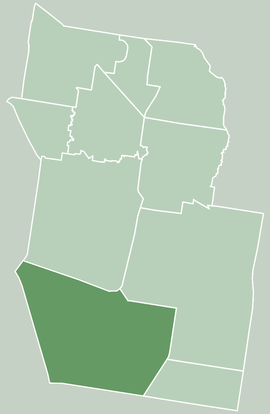 Map of City of Greater Dandenong showing Bangholme | |||||||||||||||
| Coordinates | 38°02′56″S 145°09′58″E / 38.049°S 145.166°ECoordinates: 38°02′56″S 145°09′58″E / 38.049°S 145.166°E | ||||||||||||||
| Population | 784 (2016 census)[1] | ||||||||||||||
| • Density | 26/km2 (68/sq mi) | ||||||||||||||
| Established | 1925 | ||||||||||||||
| Postcode(s) | 3175 | ||||||||||||||
| Area | 30 km2 (11.6 sq mi) | ||||||||||||||
| Location | |||||||||||||||
| LGA(s) | City of Greater Dandenong | ||||||||||||||
| State electorate(s) | |||||||||||||||
| Federal Division(s) | Isaacs | ||||||||||||||
| |||||||||||||||
Bangholme is a suburb in Melbourne, Victoria, Australia, 31 km south-east of Melbourne's central business district and adjacent to the urban area. Its local government area is the City of Greater Dandenong. At the 2016 census, Bangholme had a population of 784,[1] most of who live in the Willow Lodge Village, a mobile home development on Frankston-Dandenong Rd.
The area is semi-rural and is part of Melbourne's South East Green Wedge, with a significant part of the land used by the Melbourne Water Eastern Sewage Treatment Plant,[2] and the remainder being mostly small land holdings, with some used for horse acreage.|
The EastLink tollway passes through the area.
History
Bangholme Post Office opened on 15 June 1925, and closed in 1943.[3]
Demographics
Bangholme has a SEIFA score of 744, indicating a high level of disadvantage — it is in the bottom percentile nationally and has the lowest score of any Melbourne suburb.[4]
Sport
The National Water Sports Centre is located in Bangholme adjacent to the Patterson River.[5]
Golfers play at the course of the Eastern Sward Golf Club on Thompson Road, Bangholme.[6]
Horse riding lessons are conducted at BlinkBonnie Equestrian Centre on Pillars Road.
Horse agistment (paddocks for hire) is also available at various properties on and near Pillars Road.
See also
- City of Springvale - the former local government area of which Bangholme was a part
References
- 1 2 Australian Bureau of Statistics (27 June 2017). "Bangholme (State Suburb)". 2016 Census QuickStats. Retrieved 3 December 2017.

- ↑ Melbourne Water : Sewerage : Eastern Treatment Plant
- ↑ Premier Postal History, Post Office List, retrieved 2008-04-11
- ↑ Australian Bureau of Statistics (25 March 2009). "2033.0.55.001 - Census of Population and Housing: Socio-Economic Indexes for Areas (SEIFA), Australia - Data only, 2006". Archived from the original on 29 June 2011. Retrieved 4 July 2011.
- ↑ Sport & Recreation Victoria
- ↑ Golf Select, Eastern Sward, retrieved 2009-05-11