Głuchołazy
| Głuchołazy | |||
|---|---|---|---|
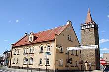
.jpg) Main square and St. Lawrence's Church | |||
| |||
 Głuchołazy | |||
| Coordinates: 50°18′47″N 17°22′27″E / 50.31306°N 17.37417°E | |||
| Country |
| ||
| Voivodeship | Opole | ||
| County | Nysa | ||
| Gmina | Głuchołazy | ||
| Town rights | 1327 | ||
| Government | |||
| • Mayor | Edward Szupryczyński | ||
| Area | |||
| • Total | 6.83 km2 (2.64 sq mi) | ||
| Population (2016) | |||
| • Total | 13,780 | ||
| • Density | 2,000/km2 (5,200/sq mi) | ||
| Time zone | UTC+1 (CET) | ||
| • Summer (DST) | UTC+2 (CEST) | ||
| Postal code | 48-340 | ||
| Area code(s) | +48 77 | ||
| Car plates | ONY | ||
| Website | http://www.glucholazy.pl | ||

Głuchołazy [ɡwuxɔˈwazɨ] (German: Bad Ziegenhals; Czech: Hlucholazy) is a town in southwestern Poland with approximately 13,780 inhabitants (2016). It is located within the Nysa County of Opole Voivodeship, near the border with the Czech Republic, and is the administrative seat of Gmina Głuchołazy. Głuchołazy has a canting arms - the shield features a goat's head in reference to its former German name, Ziegenhals, which literally means "goat's neck". The archaic Polish name for the town is Cygenhals.
Geography
The town is located in the historic Upper Silesia region on the northern slopes of the Opawskie Mountains, in the valley of the Biała River. As of 2016, it has 13,780 inhabitants.
History
The settlement in the episcopal Duchy of Nysa was established about 1220 by German settlers who were called by the ruling Bishop Lawrence of Wrocław to build up a stronghold against the threatening forces of the Přemyslid margrave Vladislaus III of Moravia, brother of King Ottokar I of Bohemia. The place soon became an important site of iron ore and gold mining run by the Thurzó and Fugger families, it had received town privileges already in 1263. The town was devastated in 1428 during the Hussite Wars.
After the First Silesian War and the 1742 Treaty of Breslau the Duchy of Nysa was partitioned and Głuchołazy became a Prussian bordertown, while the adjacent area around Zlaté Hory remained with Austrian Silesia. In the 19th century it became a spa town (Bad). After World War II the remaining German population was expelled and with the implementation of the Oder-Neisse line in 1945, the area was transferred to the Republic of Poland.
International relations
Twin towns — Sister cities
Głuchołazy is twinned with:
Notable people
- Roland Gumpert (born 1944), engineer and founder of the Gumpert sports car company
- Andrzej Sośnierz (born 1951), politician and physician
- Michał Bajor (born 1957), actor and musician
- Roman Dąbrowski (born 1972), footballer
External links
| Wikimedia Commons has media related to Głuchołazy. |
- Official town webpage (in Polish)
- Głuchołazy Unofficial Website (in Polish)
- Głuchołazy Panorama (in Polish)
- Głuchołazy in Photography (in Polish)
- Jewish Community in Głuchołazy on Virtual Shtetl
Coordinates: 50°19′N 17°22′E / 50.317°N 17.367°E
| Town and seat |  | |
|---|---|---|
| Villages | ||