Axedale
| Axedale Victoria | |
|---|---|
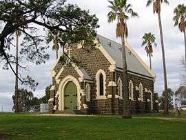 Roman Catholic church | |
 Axedale | |
| Coordinates | 36°48′S 144°31′E / 36.800°S 144.517°ECoordinates: 36°48′S 144°31′E / 36.800°S 144.517°E |
| Population | 1,523 (2011 census)[1] |
| Postcode(s) | 3551 |
| Location | |
| LGA(s) | City of Greater Bendigo |
| State electorate(s) | Bendigo East |
| Federal Division(s) | Bendigo |
Axedale is a small town in Victoria, Australia. It is located on the McIvor Highway, in the City of Greater Bendigo, east of Bendigo. It was surveyed and proclaimed in 1861. At the 2011 census, Axedale had a population of 874.[1]
The town is nestled alongside the Campaspe River which feeds out of Lake Eppalock (about 20 minutes drive away). It has a golf course, tennis courts, a school, a pub and a convenience store/petrol station and a small community of artists. It lies between Heathcote and Bendigo.
The Post Office opened on 21 April 1862. A Post Office nearby named Axe Creek Railway Station opened on 1 March 1889 when the railway arrived (named Longlea in 1904 and closing in 1989).[2]
The town was the end point of the O'Keefe Rail Trail from Bendigo. In 2015, work was completed on extending the rail trail from Axedale to Heathcote. As part of the Campaspe River crossing, an underpass for the Rail Trail was also built under the McIvor Highway.
Golfers play at the Axedale Golf Club on Mitchell Street.[3]
References
- 1 2 Australian Bureau of Statistics (31 October 2012). "Axedale (State Suburb)". 2011 Census QuickStats. Retrieved 2014-06-04.

- ↑ Premier Postal History, Post Office List, retrieved 2008-04-11
- ↑ Golf Select, Axedale, retrieved 2009-05-11
External links
![]()