Pic d'Anie
| Pic d'Anie | |
|---|---|
| Auñamendi | |
 Pic d'Anie | |
| Highest point | |
| Elevation | 2,507 m (8,225 ft) |
| Prominence | 844 m (2,769 ft) |
| Coordinates | 42°56′42″N 00°43′16″W / 42.94500°N 0.72111°WCoordinates: 42°56′42″N 00°43′16″W / 42.94500°N 0.72111°W |
| Geography | |
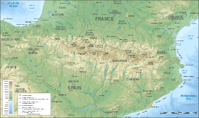 Pic d'Anie Location in the Pyrenees | |
| Location | Pyrénées-Atlantiques, France |
| Parent range | Pyrenees |
| Climbing | |
| Easiest route | Belagua, St Martin and Lescun |
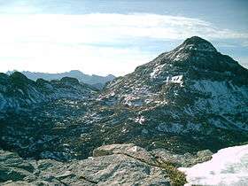
Pic d'Anie (Basque Auñamendi) is a mountain of the Pyrenees in France, located close to the Spanish border. It is 2,507 metres (8,225 ft) high.
The mountain boasts an almost perfect pyramidal shape and is surrounded by the spectacular karst landscape of. Larra, in the Larra-Belagua massif (Navarre).
The three main access routes to the peak are: Belagua in Spain and Pierre-Saint Martin and Lescun in the French department of Pyrénées-Atlantiques.
References
![]()
This article is issued from
Wikipedia.
The text is licensed under Creative Commons - Attribution - Sharealike.
Additional terms may apply for the media files.