Armeleuteberg
| Armeleuteberg | |
|---|---|
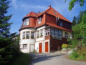 Armeleuteberg - the forest inn | |
| Highest point | |
| Elevation | 477.8 m (1,568 ft) |
| Coordinates | 51°48′59″N 10°46′53″E / 51.816357°N 10.78133°ECoordinates: 51°48′59″N 10°46′53″E / 51.816357°N 10.78133°E |
| Geography | |
 Armeleuteberg | |
| Parent range | Harz Mountains |
The Armeleuteberg is a 478 metre high hill south of Wernigerode in the district of Harz in the German state of Saxony-Anhalt. Since 1902 the Kaiserturm, an observation tower, has stood on its summit. Between the Kaiserturm and the Försterplatz car park is the forest inn of the same name.
The Armeleuteberg inn is checkpoint no. 35 in Harzer Wandernadel hiking trail network.
External links
This article is issued from
Wikipedia.
The text is licensed under Creative Commons - Attribution - Sharealike.
Additional terms may apply for the media files.