Arizona Sun Corridor
| Arizona Sun Corridor | |
|---|---|
| Megaregion of the U.S. | |
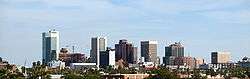   Counter Clock-wise from Top: Downtown Phoenix skyline, Downtown Tucson, Mesa City Hall
 Phoenix Tucson Sierra Vista Casa Grande Nogales Prescott Selected cities of the Arizona Sun Corridor | |
| Coordinates: 33°N 112°W / 33°N 112°WCoordinates: 33°N 112°W / 33°N 112°W | |
| Country | USA |
| State | Arizona |
| Population (2010) | |
| • Total | 5,517,131 |
| • Rank | 10th |
| • 2025 Projection | 7,764,211 |
| • 2050 Projection | 12,319,771 |
| [1] | |
The Arizona Sun Corridor, shortened Sun Corridor, is a megaregion, or megapolitan area, in the southern area of the U.S. state of Arizona. The Sun Corridor is equivalent to Indiana in both size and population. It is one of the fastest growing conurbations in the country and is speculated to double its population by 2040.[2] The largest metropolitan areas are the Phoenix metropolitan area - Valley of the Sun - and the Tucson metropolitan area. The regions' populace is nestled in the valley of a desert environment.[2] Similar to Southern California, the urban area extends into Mexico, reaching the communities of Nogales and Agua Prieta.[2]
Its population is composed of a total of five metropolitan areas: Phoenix, Tucson, Prescott, Sierra Vista-Douglas[3] and Nogales. Out of these, two are metropolitan areas with over 1,000,000 residents: the Phoenix metropolitan area with 4,192,887 residents and the Tucson metropolitan area with 1,020,200 residents. The Arizona Sun Corridor is made up of all of Maricopa, Pinal and Pima counties, along with parts of Yavapai, Santa Cruz and Cochise counties.[4] It is home to over 86 percent of Arizona's population.
The Megaregion has an area a population that is about the same as the state of Indiana (About 5.6 million people), and it is expected to grow to nearly 7.8 million by 2025. By 2050, it is projected to grow to more than twice its original size (12.3 million, about 118% growth and 6.66 million additional people). It comprises about 2% of the population of the entire United States, and it makes up about the same proportion of the total GDP, with an output of $191,036,000,000 in 2005.
Most of the Arizona Sun Corridor is in the Sonoran Desert; to the south of the region is the border between the United States and Mexico, and to the east is the Arizona transition zone and the Mountains of Arizona. The Southern California Megaregion is to west and is the nearest other Megaregion to the Arizona Sun Corridor.
Extent
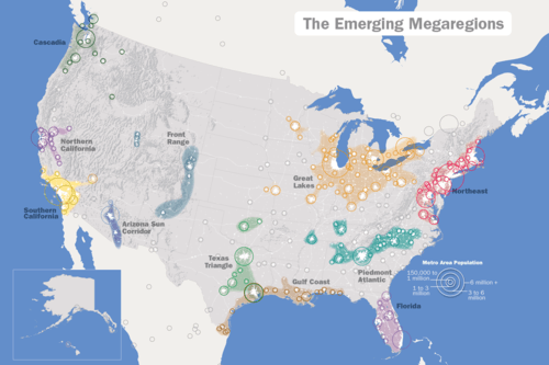

The Arizona Sun Corridor lies in the American Southwest, about halfway between the Southern California and Front Range Megaregions. It is shown on the map in deep blue.
Below is a table listing all communities of the Arizona Sun Corridor with a population of at least 10,000 residents.
| Name | Type[5] | County | Population (2010)[6] |
Area (2010)[7] | Population density (2010)[7] | ||
|---|---|---|---|---|---|---|---|
| sq mi | km2 | /sq mi | /km2 | ||||
| Anthem | CPD | Maricopa | 21,700 | ||||
| Apache Junction | City | Pinal | 35,840 | 35.00 | 90.6 | 1,024.2 | 395.4 |
| Arizona City | CPD | Pinal | 10,475 | ||||
| Avondale | City | Maricopa | 76,238 | 45.65 | 118.2 | 1,672.0 | 645.6 |
| Buckeye | City | Maricopa | 50,876 | 375.39 | 972.3 | 135.6 | 52.4 |
| Camp Verde | Town | Yavapai | 10,873 | 43.15 | 111.8 | 252.0 | 97.3 |
| Casa Grande | City | Pinal | 48,571 | 109.67 | 284.0 | 442.9 | 171.0 |
| Casas Adobes | CPD | Pima | 66,795 | ||||
| Catalina Foothills | CPD | Pima | 50,796 | ||||
| Chandler | City | Maricopa | 236,123 | 64.52 | 167.1 | 3,665.8 | 1,415.4 |
| Chino Valley | Town | Yavapai | 10,817 | 63.43 | 164.3 | 170.7 | 65.9 |
| Coolidge | City | Pinal | 11,825 | 56.58 | 146.5 | 209.3 | 80.8 |
| Cottonwood | City | Yavapai | 11,265 | 16.41 | 42.5 | 686.5 | 265.1 |
| Douglas | City | Cochise | 17,378 | 9.98 | 25.8 | 1,741.0 | 672.2 |
| Drexel Heights | CPD | Pima | 27,749 | ||||
| El Mirage | City | Maricopa | 31,797 | 10.09 | 26.1 | 3,170.7 | 1,224.2 |
| Eloy | City | Pinal | 16,631 | 111.57 | 289.0 | 149.1 | 57.6 |
| Florence | Town | Pinal | 25,536 | 52.49 | 135.9 | 486.9 | 188.0 |
| Flowing Wells | CPD | Pima | 16,419 | ||||
| Fountain Hills | Town | Maricopa | 22,489 | 20.42 | 52.9 | 1,106.2 | 427.1 |
| Gilbert | Town | Maricopa | 208,453 | 68.15 | 176.5 | 3,067.2 | 1,184.3 |
| Glendale | City | Maricopa | 226,721 | 60.13 | 155.7 | 3,780.2 | 1,459.5 |
| Gold Canyon | CPD | Pinal | 10,159 | ||||
| Goodyear | City | Maricopa | 65,275 | 191.52 | 496.0 | 340.9 | 131.6 |
| Green Valley | CPD | Pima | 21,391 | ||||
| Marana | Town | Pima | 34,961 | 122.20 | 316.5 | 287.8 | 111.1 |
| Maricopa | City | Pinal | 43,482 | 47.57 | 123.2 | 916.0 | 353.7 |
| Mesa | City | Maricopa | 439,041 | 137.06 | 355.0 | 3,217.5 | 1,242.3 |
| New River | CPD | Maricopa | 14,952 | ||||
| Nogales | City | Santa Cruz | 20,837 | 20.84 | 54.0 | 1,001.0 | 386.5 |
| Oro Valley | Town | Pima | 41,011 | 35.64 | 92.3 | 1,154.3 | 445.7 |
| Paradise Valley | Town | Maricopa | 12,820 | 15.46 | 40.0 | 830.9 | 320.8 |
| Peoria | City | Maricopa | 154,065 | 177.97 | 460.9 | 883.4 | 341.1 |
| Phoenix | City | Maricopa | 1,445,632 | 517.95 | 1,341.5 | 2,797.8 | 1,080.2 |
| Prescott | City | Yavapai | 39,843 | 41.58 | 107.7 | 963.8 | 372.1 |
| Prescott Valley | Town | Yavapai | 38,822 | 38.65 | 100.1 | 1,004.4 | 387.8 |
| Queen Creek | Town | Maricopa | 26,361 | 28.07 | 72.7 | 940.1 | 363.0 |
| Rio Rico | CPD | Santa Cruz | 18,962 | ||||
| San Tan Valley | CPD | Pinal | 81,321 | ||||
| Sahuarita | Town | Pima | 25,259 | 31.04 | 80.4 | 813.8 | 314.2 |
| Scottsdale | City | Maricopa | 217,385 | 184.40 | 477.6 | 1,182.0 | 456.4 |
| Sedona | City | Yavapai | 10,031 | 19.18 | 49.7 | 524.1 | 202.4 |
| Sierra Vista | City | Cochise | 43,888 | 152.54 | 395.1 | 288.2 | 111.3 |
| Sierra Vista Southeast | CPD | Cochise | 14,797 | ||||
| Sun City | CPD | Maricopa | 37,499 | ||||
| Sun City West | CPD | Maricopa | 24,535 | ||||
| Sun Lakes | CPD | Maricopa | 13,975 | ||||
| Surprise | City | Maricopa | 117,517 | 105.87 | 274.2 | 1,111.3 | 429.1 |
| Tanque Verde | CPD | Pima | 16,901 | ||||
| Tempe | City | Maricopa | 161,719 | 40.19 | 104.1 | 4,050.1 | 1,563.8 |
| Tucson | City | Pima | 520,116 | 227.03 | 588.0 | 2,294.2 | 885.8 |
| Tucson Estates | CPD | Pima | 12,192 | ||||
| Vail | CPD | Pima | 10,208 | ||||
| Verde Village | CPD | Yavapai | 11,605 | ||||
Transportation
Road
Intercity in the region is provided by the I-8, I-10, I-17, and I-19 freeways, as well as US 60, SR 87, SR 90, and SR 77, among other surface highways.
Phoenix area arterials are set up in a grid pattern, which helps simplify transportation within the region. Tucson's streets have a similar system.
Rail
Amtrak's Sunset Limited operates three times a week, connecting Maricopa, Arizona and Tucson. There is no other intercity rail in the region; however a high-speed rail corridor is also being studied between Phoenix and Tucson.[8]
Intracity rail systems include the Valley Metro Rail, which operates within the Phoenix metropolitan area, connecting Uptown and Downtown Phoenix with Tempe and Mesa, and Tucson's Sun Link streetcar system, which links Downtown Tucson and the Mercado district to the University of Arizona.
Air
Phoenix Sky Harbor International Airport and Tucson International Airport provide air transportation to the region, from both within the country and from a few foreign countries, among other smaller airports, which focus on regional air traffic from nearby. Recently, Phoenix-Mesa Gateway Airport, previously being a military base, has also become an option for low-cost carriers to fly into the Phoenix area as well.
US Airways, now owned by Fort Worth company American Airlines, was once headquartered and based in Tempe, which is in the Phoenix Valley. However, American Airlines maintains a strong presence in the state due to the history with US Airways.
References
- ↑ http://www.america2050.org/arizona_sun_corridor.html
- 1 2 3 "Arizona Sun Corridor". America 2050. Retrieved March 21, 2011.
- ↑ Arizona Has a New Metropolitan Area: Sierra Vista-Douglas 1-14-14.
- ↑ "Maps - America2050". America 2050. Retrieved March 20, 2011.
- ↑ "About the League: Member Cities and Towns". Arizona League of Cities and Towns. Archived from the original on 2012-02-14. Retrieved 2009-08-09.
- ↑ "Annual Estimates of the Population for Incorporated Places in Arizona". United States Census Bureau. 2009-07-07. Archived from the original on 2009-07-10. Retrieved 2009-07-21.
- 1 2 "Population, Housing Units, Area, and Density: 2010 - State -- Place, 2010 Census Summary File 1". United States Census Bureau. Retrieved 2012-05-02.
- ↑ http://www.azdot.gov/planning/CurrentStudies/PassengerRail/overview