Aridagawa, Wakayama
| Aridagawa 有田川町 | |||
|---|---|---|---|
| Town | |||
 Aridagawa Town hall | |||
| |||
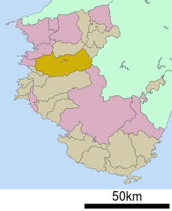 Location of Aridagawa in Wakayama Prefecture | |||
 Aridagawa Location in Japan | |||
| Coordinates: 34°3′N 135°13′E / 34.050°N 135.217°ECoordinates: 34°3′N 135°13′E / 34.050°N 135.217°E | |||
| Country | Japan | ||
| Region | Kansai | ||
| Prefecture | Wakayama Prefecture | ||
| District | Arida | ||
| Government | |||
| • Mayor | Masataka Nakayama | ||
| Area | |||
| • Total | 351.77 km2 (135.82 sq mi) | ||
| Population (October 1, 2016) | |||
| • Total | 26,245 | ||
| • Density | 75/km2 (190/sq mi) | ||
| Symbols | |||
| • Tree | Citrus unshiu | ||
| • Flower | Cosmos | ||
| • Bird | Varied tit | ||
| Time zone | UTC+9 (JST) | ||
| City hall address |
2018-4 Shimotsuno, Aridagawa, Arida, Wakayama, Japan 643-0021 | ||
| Website |
www | ||


Aridagawa (有田川町 Aridagawa-chō) is a town located in Arida District, in central Wakayama Prefecture, Japan.
It was established on January 1, 2006, by the merger of the towns of Kanaya, Kibi and Shimizu, all from Arida District.
As of October 1, 2016, those towns had a combined population of 26,245 and an area of 351.77 km2.
Geography
Aridagawa is situated nearly in the centre of Wakayama prefecture, and Aridagawa river runs through the town.
- Mountains: Mt. Washigamine (589m)
- Flatlands: Aridagawa Plain
- Rivers: Aridagawa River (Futagawa Dam)
Neighbouring cities and towns
- Wakayama Prefecture
- Arida City, Kainan City, Tanabe City
- Arida District: Yuasa Town, Hirogawa Town
- Kaisō District: Kimino Town
- Hidaka District: Hidakagawa Town
- Ito District: Katsuragi Town
- Nara Prefecture
External links

- Aridagawa official website (in Japanese)
This article is issued from
Wikipedia.
The text is licensed under Creative Commons - Attribution - Sharealike.
Additional terms may apply for the media files.