Argos
| Argos Άργος | ||
|---|---|---|
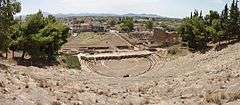
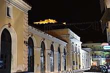
.JPG) View of Argos, seen from the ancient theatre | ||
| ||
 Argos Location within the regional unit 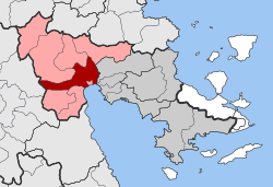 | ||
| Coordinates: 37°37′N 22°43′E / 37.617°N 22.717°ECoordinates: 37°37′N 22°43′E / 37.617°N 22.717°E | ||
| Country | Greece | |
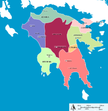
| Administrative region | Peloponnese | |
| Regional unit | Argolis | |
| Municipality | Argos-Mykines | |
| • Municipal unit | 138.138 km2 (53.335 sq mi) | |
| Elevation | 42 m (138 ft) | |
| Population (2011)[1] | ||
| • Municipal unit | 22,209 | |
| • Municipal unit density | 160/km2 (420/sq mi) | |
| Community[1] | ||
| • Population | 24,700 (2011) | |
| Time zone | UTC+2 (EET) | |
| • Summer (DST) | UTC+3 (EEST) | |
| Postal code | 21200 | |
| Area code(s) | 2751 | |
| Vehicle registration | AP | |
| Website | www.argos.gr | |

Argos (/ˈɑːrɡɒs,
Since the 2011 local government reform it has been part of the municipality of Argos-Mykines, of which it is a municipal unit.[3] The municipal unit has an area of 138.138 km2.[4] It is 11 kilometres (7 miles) from Nafplion, which was its historic harbour. A settlement of great antiquity, Argos has been continuously inhabited as at least a substantial village for the past 7,000 years.[2]:121- The city is a member of the Most Ancient European Towns Network.[5]
A resident of the city of Argos is known as an Argive (/ˈɑːrɡaɪv/ AR-ghyve, /-dʒaɪv/ -jyve; Greek: Ἀργεῖος). However, this term is also used to refer to those ancient Greeks generally who assaulted the city of Troy during the Trojan War; the term is more widely applied by the Homeric bards.
Numerous ancient monuments can be found in the city today. Agriculture is the mainstay of the local economy.
Geography
Climate
| Climate data for Argos, Greece | |||||||||||||
|---|---|---|---|---|---|---|---|---|---|---|---|---|---|
| Month | Jan | Feb | Mar | Apr | May | Jun | Jul | Aug | Sep | Oct | Nov | Dec | Year |
| Average high °F (°C) | 58 (14) |
58 (14) |
61 (16) |
66 (19) |
72 (22) |
79 (26) |
83 (28) |
85 (29) |
81 (27) |
75 (24) |
67 (19) |
61 (16) |
70.5 (21.4) |
| Average low °F (°C) | 45 (7) |
45 (7) |
47 (8) |
52 (11) |
58 (14) |
65 (18) |
70 (21) |
71 (22) |
66 (19) |
60 (16) |
54 (12) |
48 (9) |
56.75 (13.75) |
| Source: "Argos Monthly Climate Average, Greece". World Weather Online. 2016. Retrieved 13 September 2016. | |||||||||||||
Etymology
The name of the city is very ancient and several etymological theories have been proposed as an explanation to its meaning. The most popular one maintains that the name of the city is a remainder from the Pelasgian language, i.e. the one used by the people who first settled in the area, in which Argos meant "plain". Alternatively, the name is associated with Argos, the third king of the city in ancient times, who renamed it after himself, thus replacing its older name Phoronikon Astu (Φορωνικόν Άστυ, "city of Phoroneus"). It is also believed that "Argos" is linked to the word "αργός" (argós), which meant "white"; possibly, this had to do with the visual impression given of the argolic plain during harvest time. According to Strabo, the name could have even originated from the word "αγρός" (=field) by antimetathesis of the consonants.[6]
History
Antiquity
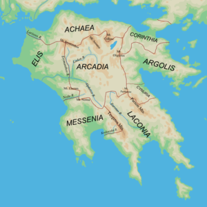
Argos is traditionally considered to be the origins of the ancient Macedonian royal Greek house of the Argead dynasty (Greek: Ἀργεάδαι, Argeádai).The most celebrated members were Philip II of Macedon and Alexander the Great. As a strategic location on the fertile plain of Argolis, Argos was a major stronghold during the Mycenaean era. In classical times Argos was a powerful rival of Sparta for dominance over the Peloponnese, but was eventually shunned by other Greek city-states after remaining neutral during the Greco-Persian Wars.[7]
There is evidence of continuous settlement in the area starting with a village about 7000 years ago in the late Neolithic, located on the foot of Aspida hill.[2]:124- Since that time, Argos has been continually inhabited at the same geographical location. Its creation is attributed to Phoroneus, with its first name having been Phoronicon Asty, or the city of Phoroneus. The historical presence of the Pelasgian Greeks in the area can be witnessed in the linguistic remainders that survive up to today, such as the very name of the city and "Larisa", the name of the city's castle located on the hill of the name.[8]
The city is located at a rather propitious area, among Nemea, Corinth and Arcadia. It also benefitted from its proximity to lake Lerna, which, at the time, was at a distance of one kilometre from the south end of Argos.
Argos was a major stronghold of Mycenaean times, and along with the neighbouring acropolis of Mycenae and Tiryns became a very early settlement because of its commanding positions in the midst of the fertile plain of Argolis. Argos experienced its greatest period of expansion and power under the energetic 7th century BC ruler King Pheidon. Under Pheidon, Argos regained sway over the cities of the Argolid and challenged Sparta’s dominance of the Peloponnese. Spartan dominance is thought to have been interrupted following the Battle of Hyssii in 698 BC, in which Argive troops defeated the Spartans in a hoplite battle.[9] During this time of its greatest power, the city boasted a pottery and bronze sculpturing school, pottery workshops, tanneries and clothes producers. Moreover, at least 25 celebrations took place in the city, in addition to a regular local products exhibition.[10] A sanctuary dedicated to Hera was also found at the same spot where the monastery of Panagia Katekrymeni is located today. Pheidon also extended Argive influence throughout Greece, taking control of the Olympic Games away from the citizens of Elis and appointing himself organizer during his reign.[9] Pheidon is also thought to have introduced reforms for standard weight and measures in Argos, a theory further reinforced with the unearthing of six "spits" of iron in an Argive Heraion, possibly remainders of a dedication from Pheidon.[9]
Argos remained neutral or the ineffective ally of Athens during the 5th century BC struggles between Sparta and Athens. This, however, led to its weakening and loss of power, which in turn led to the shift of commercial focus from the Ancient Agora to the eastern side of the city, delimited by Danaou and Agiou Konstadinou streets. Argos played a minor role in the Corinthian Wars against Sparta, and for a short period of time considered uniting with Corinth to form an expanded Argolid state. However, this plan never came to fruition, and Argos continued to remain a minor power in Greek affairs.
Democracy in Classical Argos
Argos was a democracy for most of the classical period, with only a brief hiatus between 418 and 416.[11] Democracy was first established after a disastrous defeat by the Spartans at the battle of Sepeia in 494. So many Argives were killed in the battle that a revolution ensued, in which previously disenfranchised outsiders were included in the state for the first time.[12]
Argive democracy included an Assembly (called the aliaia), a Council (the bola), and another body called 'The Eighty,' whose precise responsibilities are obscure. Magistrates served six-month terms of office, with few exceptions, and were audited at the end of their terms. There is some evidence that ostracism was practiced.[13]
Roman, Byzantine, Crusader, Ottoman rule and independence
Under Roman rule, Argos was part of the province of Achaea. Under Byzantine rule it was part of the theme of Hellas, and later of the theme of the Peloponnese.
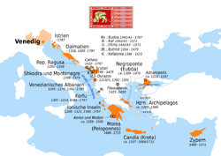
In the aftermath of the Fourth Crusade, the Crusaders captured the castle built on Larisa Hill, the site of the ancient acropolis, and the area become part of the lordship of Argos and Nauplia. In 1388 it was sold to the Republic of Venice, but was taken by the Despot of the Morea Theodore I Palaiologos before the Venetians could take control of the city; he sold it anyway to them in 1394. The Crusaders established a Latin bishopric. Venetian rule lasted until 1463, when the Ottomans captured the city.
In 1397, the Ottomans plundered Argos, carrying off much of the population,[14] to sell as slaves.[15] The Venetians repopulated the town and region with Albanian settlers,[15] granting them long-term agrarian tax exemptions.[14] Together with the Greeks of Argos, they supplied stratioti troops to the armies of Venice.[14] Some historians consider the French military term "argoulet" to derive from the Greek "argetes", or inhabitant of Argos, as a large number of French stratioti came from the plain of Argos.[16]
During Ottoman rule, Argos was divided in four mahalas, or quarters; the Greek (Rûm) mahala, Liepur mahala, Bekir Efenti mahala and Karamoutza or Besikler mahala, respectively corresponding to what is now the northeastern, the northwestern, the southwestern and southeastern parts of the city. The Greek mahala was also called the "quarter of the unfaithful of Archos town" in Turkish documents, whereas Liepur mahala (the quarter of the rabbits) was composed mostly of Albanian emigrants and well-reputed families. Karamoutza mahala was home to the most prominent Turks and boasted a mosque (modern-day church of Agios Konstadinos), a Turkish cemetery, Ali Nakin Bei's serail, Turkish baths and a Turkish school. It is also at this period when the open market of the city is first organised on the site north to Kapodistrias' barracks, at the same spot where it is held in modern times. A mosque would have existed there, too, according to the city planning most Ottoman cities followed.
Argos grew exponentially during this time, with its sprawl being unregulated and without planning. As French explorer Pouqueville noted, "its houses are not aligned, without order, scattered all over the place, divided by home gardens and uncultivated areas". Liepur mahala appears to have been the most organised, having the best layout, while Bekir mahala and Karamoutza mahala were the most labyrinthine. However, all quarters shared the same type of streets; firstly, they all had main streets which were wide, busy and public roads meant to allow for communication between neighbourhoods (typical examples are, to a great extent, modern-day Korinthou, Nafpliou and Tripoleos streets). Secondary streets were also common in all four quarters since they lead to the interior of each mahala, having a semi-public character, whereas the third type of streets referred to dead-end private alleys used specifically by families to access their homes. Remnants of this city layout can be witnessed even today, as Argos still preserves several elements of this Ottoman type style, particularly with its long and complicated streets, its narrow alleys and its densely constructed houses.
With the exception of a period of Venetian domination in 1687–1715, Argos remained in Ottoman hands until the beginning of the Greek War of Independence in 1821, when wealthy Ottoman families moved to nearby Nafplio due to its stronger walling.
At that time, as part of the general uprising, many local governing bodies were formed in different parts of the country, and the "Consulate of Argos" was proclaimed on 28 March 1821, under the Peloponnesian Senate. It had a single head of state, Stamatellos Antonopoulos, styled "Consul", between 28 March and 26 May 1821.
Later, Argos accepted the authority of the unified Provisional Government of the First National Assembly at Epidaurus, and eventually became part of the Kingdom of Greece. With the coming of governor Ioannis Kapodistrias, the city underwent efforts of modernisation. Being an agricultural village, the need for urban planning was vital. For this reason, in 1828, Kapodistrias himself appointed mechanic Stamatis Voulgaris as the creator of a city plan which would offer Argos big streets, squares and public spaces. However, both Voulgaris and, later, French architect de Borroczun's plans were not well received by the locals, with the result that the former had to be revised by Zavos. Ultimately, none of the plans were fully implemented. Still, the structural characteristics of de Borroczun's plan can be found in the city today, despite obvious proof of pre-revolutionary layout, such as the unorganised urban sprawl testified in the area from Inachou street to the point where the railway tracks can be found today.
After talks concerning the intentions of the Greek government to move the Greek capital from Nafplio to Athens, discussions regarding the possibility of Argos also being a candidate as the potential new capital became more frequent, with supporters of the idea claiming that, unlike Athens, Argos was naturally protected by its position and benefited from a nearby port (Nafplio). Moreover, it was maintained that construction of public buildings would be difficult in Athens, given that most of the land was owned by the Greek church, meaning that a great deal of expropriation would have to take place. On the contrary, Argos did not face a similar problem, having large available areas for this purpose. In the end, the proposition of the Greek capital being moved to Argos was rejected by the father of king Otto, Ludwig, who insisted in making Athens the capital, something which eventually happened in 1834.[17]
Mythology
The mythological kings of Argos are (in order): Inachus, Phoroneus, Argus, Triopas, Agenor, Iasus, Crotopus, Pelasgus (aka Gelanor), Danaus, Lynceus, Abas, Proetus, Acrisius, Perseus, Megapenthes, Argeus and Anaxagoras. An alternative version supplied by Tatian of the original 17 consecutive kings of Argos includes Apis, Argios, Kriasos and Phorbas between Argus and Triopas, explaining the apparent unrelation of Triopas to Argus.[18]
The city of Argos was believed to be the birthplace of the mythological character Perseus, the son of the god Zeus and Danaë, who was the daughter of the king of Argos, Acrisius.
After the original 17 kings of Argos, there were three kings ruling Argos at the same time (see Anaxagoras), one descended from Bias, one from Melampus, and one from Anaxagoras. Melampus was succeeded by his son Mantius, then Oicles, and Amphiaraus, and his house of Melampus lasted down to the brothers Alcmaeon and Amphilochus.
Anaxagoras was succeeded by his son Alector, and then Iphis. Iphis left his kingdom to his nephew Sthenelus, the son of his brother Capaneus.
Bias was succeeded by his son Talaus, and then by his son Adrastus who, with Amphiaraus, commanded the disastrous Seven Against Thebes. Adrastus bequeathed the kingdom to his son, Aegialeus, who was subsequently killed in the war of the Epigoni. Diomedes, grandson of Adrastus through his son-in-law Tydeus and daughter Deipyle, replaced Aegialeus and was King of Argos during the Trojan war. This house lasted longer than those of Anaxagoras and Melampus, and eventually the kingdom was reunited under its last member, Cyanippus, son of Aegialeus, soon after the exile of Diomedes.
Ecclesiastical history
After Christianity became established in Argos, the first bishop documented in extant written records is Genethlius, who in 448 AD took part in the synod called by Archbishop Flavian of Constantinople that deposed Eutyches from his priestly office and excommunicated him. The next bishop of Argos, Onesimus, was at the 451 Council of Chalcedon. His successor, Thales, was a signatory of the letter that the bishops of the Roman province of Hellas sent in 458 to Byzantine Emperor Leo I the Thracian to protest about the killing of Proterius of Alexandria. Bishop Ioannes was at the Third Council of Constantinople in 680, and Theotimus at the Photian Council of Constantinople (879).[19] The local see is today the Greek Orthodox Metropolis of Argolis.
Under 'Frankish' Crusader rule, Argos became a Latin Church bishopric in 1212, which lasted as a residential see until Argos was taken by the Ottoman Empire in 1463 [20] but would be revived under the second Venetian rule in 1686. Today the diocese is a Catholic titular see.
Characteristics
Orientation
The city of Argos is delimited to the north by dry river Xerias, to the east by Inachos river and Panitsa stream (which emanates from the latter), to the west by the Larissa hill (site of homonymous castle and of a monastery called Panagia Katakekrymeni-Portokalousa) and the Aspidos Hill (unofficially Prophetes Elias hill), and to the south by the Notios Periferiakos road.
The Agios Petros (Saint Peter) square, along with the eponymous cathedral (dedicated to saint Peter the Wonderworker), make up the town centre, whereas some other characteristic town squares are the Laiki Agora (Open Market) square, officially Dimokratias (Republic) square, where, as implied by its name, an open market takes place twice a week, Staragora (Wheat Market), officially Dervenakia square, and Dikastirion (Court) square. Bonis Park is an essential green space of the city.
Currently, the most commercially active streets of the city are those surrounding the Agios Petros square (Kapodistriou, Danaou, Vassileos Konstantinou streets) as well as Korinthou street. The Pezodromi (Pedestrian Streets), i.e. the paved Michael Stamou, Tsaldari and Venizelou streets, are the most popular meeting point, encompassing a wide variety of shops and cafeterias.
Population
In 700 BC there were at least 5,000 people living in the city.[21] In the fourth century BC, the city was home to as many as 30,000 people.[22] Today, according to the 2011 Greek census, the city has a population of 22,209. It is the largest city in Argolis, larger than the capital Nafplio.
Economy
The primary economic activity in the area is agriculture. Citrus fruits are the predominant crop, followed by olives and apricots. The area is also famous for its local melon variety, Argos melons (or Argetiko). There is also important local production of dairy products, factories for fruits processing.
Considerable remains of the ancient and medieval city survive and are a popular tourist attraction.
Monuments
Most of Argos' historical and archaeological monuments are currently unused, abandoned, or only partially renovated:
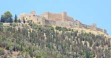
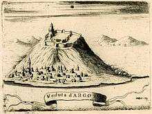
- The Larisa castle, built during prehistoric time, which has undergone several repairs and expansions since antiquity and played a significant historical role during the Venetian domination of Greece and the Greek War of Independence.[8] It is located on top of the homonymous Larisa Hill, which also constitutes the highest spot of the city (289 m.). In ancient times, a castle was also found in neighbouring Aspida Hill. When connected with walls, these two castles fortified the city from enemy invasions.
- The Ancient theatre, built in the 3rd century B.C with a capacity of 20,000 spectators, replaced an older neighbouring theatre of the 5th century BC and communicated with the Ancient Agora. It was visible from any part of the ancient city and the Argolic gulf. In 1829, it was used by Ioannis Kapodistrias for the Fourth National Assembly of the new Hellenic State. Today, cultural events are held at its premises during the summer months.[23]
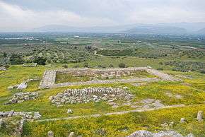
- The Ancient Agora, adjacent to the Ancient theatre, which developed in the 6th century B.C., was located at the junction of the ancient roads coming from Corinth, Heraion and Tegea. Excavations in the area have uncovered a bouleuterion, built in 460 B.C. when Argos adopted the democratic regime, a Sanctuary of Apollo Lyceus and a palaestra.[24]
- The "Criterion" of Argos, an ancient monument located on the southwest side of the town, on the foot of Larissa hill, which came to have its current structure during the 6th-3rd century BC period. Initially, it served as a court of ancient Argos, similar to Areopagus of Athens. According to mythology, it was at this area where Hypermnestra, one of the 50 daughters of Danaus, the first king of Argos, was tried. Later, under the reigns of Hadrian, a fountain was created to collect and circulate water coming from the Hadrianean aqueduct located in northern Argos. The site is connected via a paved path with the ancient theatre.[25]
- The Barracks of Kapodistrias, a preservable building with a long history. Built in the 1690s during the Venetian domination of Greece, they initially served as a hospital run by the Sisters of Mercy. During the Tourkokratia, they served as a market and a post office. Later, in 1829, significant damage caused during the Greek revolution was repaired by Kapodistrias who turned the building into a cavalry barrack, a school (1893-1894), an exhibition space (1899), a shelter for Greek refugees displaced during the population exchange between Greece and Turkey (since 1920) and an interrogation and torture space (during the German occupation of Greece). In 1955-68, it was used by the army for the last time; it now accommodates the Byzantine Museum of Argos, local corporations and also serves as an exhibition space.[26]
- The Municipal Neoclassical Market building (unofficially the "Kamares", i.e. arches, from the arches that it boasts), built in 1889, which is located next to Dimokratias square, is one of the finest samples of modern Argos' masterly architecture, in Ernst Ziller style. The elongated, two corridor, preservable building accommodates small shops.[27]
- The Kapodistrian school, in central Argos. Built by architect Labros Zavos in 1830, as part of Kapodistrias' efforts to provide places of education to the Greek people, it could accommodate up to 300 students. However, technical difficulties led to its decay, until it was restored several times, the last of which being in 1932. Today, its neoclassical character is evident, with the building housing the 1st elementary school of the town.[28]
- The old Town Hall, built during the time of Kapodistrias in 1830, which originally served as a Justice of the peace, the Dimogerontia of Argos, an Arm of Carabineers and a prison. From 1987 to 2012, it housed the Town Hall which is now located in Kapodistriou street.
- The House of philhellene Thomas Gordon, built in 1829 that served as an all-girls school, a dance school and was home to the 4th Greek artillery regiment. Today it accommodates the French Institute of Athens (Institut Français d' Athènes).[29]
- The House of Spyridon Trikoupis (built in 1900), where the politician was born and spent his childhood. Also located in the estate, which is not open to public, is the Saint Charalambos chapel where Trikoupis was baptized.[30]
- The House of general Tsokris, important military fighter in the Greek revolution of 1821 and later assemblyman of Argos.
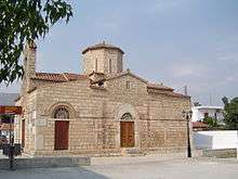
- The temple of Agios Konstadinos, one of the very few remaining buildings in Argos dating from the Ottoman Greece era. It is estimated to have been built in the 1570-1600 period, with a minaret also having existed in its premises. It served as a mosque and an Ottoman cemetery up to 1871, when it was declared a Christian temple.[31]
- The chambered tombs of the Aspidos hill.
- The Hellinikon Pyramid. Dating back to late 4th B.C., there exist many theories as to the purpose it served (tumulus, fortress). Together with the widely accepted scientific chronology, there are some people who claim it was built shortly after the Pharaoh tomb, i.e. the Great Pyramid of Giza, thus a symbol of the excellent relationship the citizens of Argos had with Egypt.
A great number of archaeological findings, dating from the prehistoric ages, can be found at the Argos museum, housed at the old building of Dimitrios Kallergis at Saint Peter's square. The Argos airport, located in an homonymous area (Aerodromio) in the outskirts of the city is also worth mentioning. The area it covers was created in 1916-1917 and was greatly used during the Greco-Italian War and for the training of new Kaberos school aviators for the Hellenic Air Force Academy. It also constituted an important benchmark in the organization of the Greek air forces in southern Greece. Furthermore, the airport was used by the Germans for the release of their aerial troops during the Battle of Crete. It was last used as a landing/take off point for spray planes (for agricultural purposes in the olive tree cultivations) up until 1985.[32]
Transportation
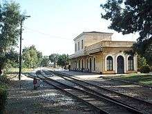
Argos is connected via regular bus services with neighbouring areas as well as Athens. In addition, taxi stands can be found at the Agios Petros as well as the Laiki Agora square. The city also has a railway station which, at the moment, remains closed due to an indefinite halt to all railway services in the Peloponnese area by the Hellenic Railways Organisation. However, in late 2014, it was announced that the station would open up again, as part of an expansion of the Athens suburban railway in Argos, Nafplio and Korinthos.[33][34]
Education
Argos has a wide range of educational institutes that also serve neighbouring sparsely populated areas and villages. In particular, the city has seven dimotika (primary schools), four gymnasia (junior high), three lyceums (senior high), one vocational school, one music school as well as a tourist Business and Cooking department and a post-graduate ASPETE department. The city also has two public libraries.[35]
Sports
Argos hosts two sport clubs with presence in higher national divisions and several achievements, Panargiakos F.C. football club, founded in 1926 and AC Diomidis Argous handball club founded in 1976. Diomidis Argos is the unique provincial Greek sport club with European cup.
| Sport clubs based in Tripoli | |||
|---|---|---|---|
| Club | Founded | Sports | Achievements |
| Panargiakos F.C. | 1926 | Football | Earlier presence in Beta Ethniki |
| AC Diomidis Argous | 1976 | Handball | Panhellenic and European titles in Greek handball |
Notable people
- Acrisius, mythological king
- Theoclymenus, mythological prophet
- Agamemnon, legendary leader of the Achaeans in the Trojan War
- Acusilaus (6th century BC), logographer and mythographer
- Ageladas (6th–5th century BC), sculptor
- Calchas (8th century BC), Homeric mythological seer
- Karanos (8th century BC), founder of the Macedonian Argead Dynasty
- Leo Sgouros (13th century), Byzantine despot
- Nikon the Metanoeite (10th century), Christian saint of Armenian origin, according to some sources born in Argos
- Pheidon (7th century BC), king of Argos
- Argus (7th century BC), king of Argos
- Polykleitos (5th–4th century BC), sculptor
- Polykleitos the Younger (4th century BC), sculptor
- Telesilla (6th century BC), Greek poet
- Bilistiche, hetaira and lover of pharaoh Ptolemy II Philadelphus
- Eleni Bakopanos (born 1954), Canadian politician
- Samuel Greene Wheeler Benjamin (1837-1914), American statesman
International relations
Twin towns & sister cities
Argos is twinned with:
Other relations
See also
Notes
- 1 2 "Απογραφή Πληθυσμού - Κατοικιών 2011. ΜΟΝΙΜΟΣ Πληθυσμός" (in Greek). Hellenic Statistical Authority.
- 1 2 3 Bolender, Douglas J. (2010-09-17). Eventful Archaeologies: New Approaches to Social Transformation in the Archaeological Record. SUNY Press. ISBN 978-1-4384-3423-0. Retrieved 1 January 2011.
- ↑ Kallikratis law Greece Ministry of Interior (in Greek)
- ↑ "Population & housing census 2001 (incl. area and average elevation)" (PDF) (in Greek). National Statistical Service of Greece. Archived from the original (PDF) on 2015-09-21.
- ↑ MAETN (1999). "diktyo". classic-web.archive.org. Archived from the original on October 22, 2005. Retrieved 19 May 2011.
- ↑ Athanasios Vercetis; Stavroula Petraki (2010). "Σεπτεμβρίου ΑΡΓΟΛΙΚΗ ΑΡΧΕΙΑΚΗ ΒΙΒΛΙΟΘΗΚΗ ΙΣΤΟΡΙΑΣ ΚΑΙ ΠΟΛΙΤΙΣΜΟΥ". argolikivivliothiki.gr (in Greek). Argolikos Archival Library of History and Culture. Archived from the original on February 5, 2018. Retrieved 5 February 2018.
- ↑ Roberts, John (2005). Dictionary of the Classical World. Oxford University Press. p. 66. ISBN 978-0-19-280146-3.
- 1 2 http://www.kastra.eu/castlegr.php?kastro=argos
- 1 2 3 Mackil, Emily, Tyrants in Seventh Century Greece, Lecture, September 20, 2018
- ↑ "Archived copy". Archived from the original on 2015-02-25. Retrieved 2015-03-06.
- ↑ E. Robinson, Democracy Beyond Athens, Cambridge, 2011, 6-21.
- ↑ Hdt. 6.83; Arist. Pol. 13036-8
- ↑ E. Robinson, Democracy Beyond Athens, Cambridge, 2011, 10-18.
- 1 2 3 Contingent countryside: settlement, economy, and land use in the southern Argolid since 1700 Authors Susan Buck Sutton, Keith W. Adams, Argolid Exploration Project Editors Susan Buck Sutton, Keith W. Adams Contributor Keith W. Adams Edition illustrated Publisher Stanford University Press, 2000 ISBN 0-8047-3315-5, ISBN 978-0-8047-3315-1 page 28
- 1 2 Eventful Archaeologies: New Approaches to Social Transformation in the Archaeological Record The Institute for European and Mediterranean Archaeology Distinguished Monograph Series Author Douglas J. Bolender Editor Douglas J. Bolender Publisher SUNY Press, 2010 ISBN 1-4384-3423-5, ISBN 978-1-4384-3423-0 page 129 link
- ↑ Pappas, Nicholas C. J. "Stradioti: Balkan Mercenaries in Fifteenth and Sixteenth Century Italy". Sam Houston State University.
- ↑ https://argolikivivliothiki.gr/2009/02/20/%CF%84%CE%BF-%CE%AC%CF%81%CE%B3%CE%BF%CF%82-%CF%80%CF%81%CE%BF%CF%84%CE%B5%CE%AF%CE%BD%CE%B5%CF%84%CE%B1%CE%B9-%CF%89%CF%82-%CF%80%CF%81%CF%89%CF%84%CE%B5%CF%8D%CE%BF%CF%85%CF%83%CE%B1-%CF%84%CE%B7/
- ↑ James Cowles Prichard : An Analysis of the Egyptian Mythology. 1819. p. 85
- ↑ Michel Lequien, Oriens christianus in quatuor Patriarchatus digestus, Paris 1740, Vol. II, coll. 183-186
- ↑ Konrad Eubel, Hierarchia Catholica Medii Aevi, vol. 1, p. 105-106; vol. 2, pp. XIV e 94; vol. 3, p. 117; vol. 4, p. 94; vol. 5, p. 98
- ↑ Urbanism in the Preindustrial World: Cross-Cultural Approaches, p. 37, at Google Books
- ↑ Geology and Settlement: Greco-Roman Patterns, p. 124, at Google Books
- ↑ "Archived copy". Archived from the original on 2015-02-21. Retrieved 2015-02-21.
- ↑ "Archived copy". Archived from the original on 2015-02-21. Retrieved 2015-02-21.
- ↑ http://argolikivivliothiki.gr/tag/%CE%B1%CE%B4%CF%81%CE%B9%CE%AC%CE%BD%CE%B5%CE%B9%CE%BF-%CF%85%CE%B4%CF%81%CE%B1%CE%B3%CF%89%CE%B3%CE%B5%CE%AF%CE%BF/
- ↑ http://argolikivivliothiki.gr/2008/10/24/%CF%83%CF%84%CF%81%CE%B1%CF%84%CF%8E%CE%BD%CE%B5%CF%82-%CE%BA%CE%B1%CF%80%CE%BF%CE%B4%CE%AF%CF%83%CF%84%CF%81%CE%B9%CE%B1-%E2%80%93-%CE%AC%CF%81%CE%B3%CE%BF%CF%82/
- ↑ http://argolikivivliothiki.gr/2011/11/16/%CE%B4%CE%B7%CE%BC%CE%BF%CF%84%CE%B9%CE%BA%CE%AE-%CE%BD%CE%B5%CE%BF%CE%BA%CE%BB%CE%B1%CF%83%CE%B9%CE%BA%CE%AE-%CE%B1%CE%B3%CE%BF%CF%81%CE%AC-%CE%AC%CF%81%CE%B3%CE%BF%CF%85%CF%82/
- ↑ https://argolikivivliothiki.gr/2009/03/11/kapodistrian-school/
- ↑ http://argolikivivliothiki.gr/2008/11/16/%CE%BF%CE%B9%CE%BA%CE%AF%CE%B1-%CE%B3%CF%8C%CF%81%CE%B4%CF%89%CE%BD%CE%BF%CF%82-%CE%AC%CF%81%CE%B3%CE%BF%CF%82/
- ↑ "Archived copy". Archived from the original on 2016-03-04. Retrieved 2015-07-29.
- ↑ https://argolikivivliothiki.gr/2010/02/19/%CE%B9%CE%B5%CF%81%CF%8C%CF%82-%CE%BD%CE%B1%CF%8C%CF%82-%CE%B1%CE%B3%CE%AF%CE%BF%CF%85-%CE%BA%CF%89%CE%BD%CF%83%CF%84%CE%B1%CE%BD%CF%84%CE%AF%CE%BD%CE%BF%CF%85-%CF%83%CF%84%CE%BF-%CE%AC%CF%81%CE%B3/
- ↑ http://argolikivivliothiki.gr/2010/01/12/h-%CF%83%CF%87%CE%BF%CE%BB%CE%AE-%CE%B9%CE%BA%CE%AC%CF%81%CF%89%CE%BD-%CF%83%CF%84%CE%BF-%CE%B1%CE%B5%CF%81%CE%BF%CE%B4%CF%81%CF%8C%CE%BC%CE%B9%CE%BF-%CF%84%CE%BF%CF%85-%CE%AC%CF%81%CE%B3%CE%BF%CF%85/
- ↑ "Archived copy". Archived from the original on 2014-09-19. Retrieved 2015-02-01.
- ↑ http://sidirodromikanea.blogspot.gr/2015/01/blog-post_64.html
- ↑ http://argolikivivliothiki.gr/2008/11/16/%CE%BC%CE%AD%CE%B3%CE%B1%CF%81%CE%BF-%C2%AB%CE%B4%CE%B1%CE%BD%CE%B1%CE%BF%CF%8D%C2%BB-%CE%AC%CF%81%CE%B3%CE%BF%CF%82/
- 1 2 3 "Twinnings" (PDF). Central Union of Municipalities & Communities of Greece. Retrieved 2013-08-25.
Sources and external links
| Wikivoyage has a travel guide for Argos. |
- Official website
- GCatholic with incumbent bio links
- The Theatre at Argos, The Ancient Theatre Archive, Theatre specifications and virtual reality tour of theatre
Stato da Màr of the Republic of Venice | ||
|---|---|---|
| Adriatic Sea |
|  |
| Ionian Islands and dependencies |
| |
| Mainland Greece |
| |
| Aegean Islands |
| |
| Other |
| |
| Related articles | ||
| Authority control |
|---|