Anthony Peak
| Anthony Peak | |
|---|---|
 Howard Lake and Leech Lake Mountain | |
| Highest point | |
| Elevation | 6,960 ft (2,121 m) NAVD 88[1] |
| Prominence | 1,514 ft (461 m) [2] |
| Listing | California county high points 31st |
| Coordinates | 39°50′47″N 122°57′53″W / 39.846254403°N 122.964612483°WCoordinates: 39°50′47″N 122°57′53″W / 39.846254403°N 122.964612483°W [1] |
| Geography | |
 Anthony Peak | |
| Parent range | Northern Coast Ranges |
| Topo map | USGS Mendocino Pass |
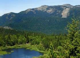
Anthony Peak is a mountain located in the Northern Coast Ranges of California north of Mendocino Pass. The summit is the highest point in Mendocino County,[2] and receives snowfall in the winter.[3]
The rare endemic wildflower known as Anthony Peak lupine (Lupinus antoninus) was named for this peak.[4] The peak was probably named for James Anthony, who owned a farm in the Round Valley district in 1874.[5]
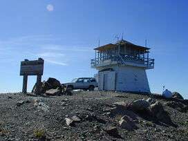
Anthony Peak Lookout
References
- 1 2 "Anthony". NGS data sheet. U.S. National Geodetic Survey. Retrieved 2009-06-30.
- 1 2 "Anthony Peak, California". Peakbagger.com. Retrieved 2009-02-02.
- ↑ "Subsection M261Ba - Eastern Franciscan". U.S. Forest Service. Archived from the original on 20 January 2009. Retrieved 2009-02-02.
- ↑ Template:Cite boeok
- ↑ Gudde, Erwin G. (1949). California Place Names. Berkeley: Univ. of California Press. p. 12.
External links
| Wikimedia Commons has media related to Anthony Peak. |
- "Anthony Peak". Geographic Names Information System. United States Geological Survey. Retrieved 2009-06-30.
This article is issued from
Wikipedia.
The text is licensed under Creative Commons - Attribution - Sharealike.
Additional terms may apply for the media files.