Ano Liosia
| Ano Liosia Άνω Λιόσια | |
|---|---|
 View of Athens from Ano Liosia | |
 Ano Liosia Location within the regional unit  | |
| Coordinates: 38°5′N 23°42′E / 38.083°N 23.700°ECoordinates: 38°5′N 23°42′E / 38.083°N 23.700°E | |
| Country | Greece |
| Administrative region | Attica |
| Regional unit | West Attica |
| Municipality | Fyli |
| • Municipal unit | 38.447 km2 (14.844 sq mi) |
| Elevation | 160 m (520 ft) |
| Population (2011)[1] | |
| • Municipal unit | 33,565 |
| • Municipal unit density | 870/km2 (2,300/sq mi) |
| Time zone | UTC+2 (EET) |
| • Summer (DST) | UTC+3 (EEST) |
| Postal code | 133 xx |
| Area code(s) | 210 |
| Vehicle registration | Z |
| Website | www.liosia.gr |
Ano Liosia (Greek: Άνω Λιόσια) is a suburb and a former municipality in the northern part of the Athens agglomeration, Greece. Since the 2011 local government reform it is part of the municipality Fyli, of which it is the seat and a municipal unit.[2] The municipal unit has an area of 38.447 km2.[3]
Geography
Ano Liosia lies in the eastern part of West Attica, between the mountains Parnitha to its north and Aigaleo to its southwest. It is 3 km west of Acharnes, 3 km north of Kamatero, 4 km southeast of Fyli, 10 km east of Aspropyrgos and 11 km north of Athens city centre.
Transportation
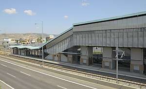
The Ano Liosia railway station is served by Proastiakos trains to the Athens International Airport and to Kiato in the Peloponnese. The railway station on the old metric Piraeus–Patras railway is now closed. Ano Liosia is connected to the rest of Athens by various bus lines, most notably the B12 and E42 lines. Motorway 6 runs south of the town.
History
On September 7, 1999, the 1999 Athens earthquake damaged between one hundred and a thousand homes. The 2007 Greek forest fires devastated the nearby forests. A remarkable number of Romani live in the area.
Population
| Year | Population |
|---|---|
| 1951 | 1,660 |
| 1961 | 3,348 |
| 1971 | 11,388 |
| 1981 | 16,862 |
| 1991 | 21,397 |
| 2001 | 26,423 |
| 2011 | 33,565 |
Sports
The 11th International Chess Tournament took place in Ano Liosia in 2001. The following sports teams are based in Ano Liosia:
- Akratitos - a Greek football/soccer team which was founded in 1963
- Das Ano Liosia - a Greek basketball team
Sports venues:
- Ano Liosia Olympic Hall where wrestling and judo were played in the 2004 Summer Olympics
- Zofria Indoor Hall - basketball arena that has been used by AEK Athens.
- Stadium for Akratitos rarely plays in this stadium
- Basketball stadium for Das Ano Liosia
- Football/soccer stadium for Akratitos
References
- ↑ "Απογραφή Πληθυσμού - Κατοικιών 2011. ΜΟΝΙΜΟΣ Πληθυσμός" (in Greek). Hellenic Statistical Authority.
- ↑ Kallikratis law Greece Ministry of Interior (in Greek)
- ↑ "Population & housing census 2001 (incl. area and average elevation)" (PDF) (in Greek). National Statistical Service of Greece. Archived from the original (PDF) on 2015-09-21.
External links
- City of Ano Liosia official website (in Greek)
- http://www.chess.gr/anoliosia/
- http://www.stadia.gr/anoliossia/anoliossia.html
Places adjacent to Ano Liosia | ||||||||||
|---|---|---|---|---|---|---|---|---|---|---|
| ||||||||||