Anjar, Gujarat
| Anjar | |
|---|---|
| Town | |
 Anjar Location in Gujarat, India  Anjar Anjar (India) | |
| Coordinates: 23°08′N 70°01′E / 23.13°N 70.02°ECoordinates: 23°08′N 70°01′E / 23.13°N 70.02°E | |
| Country |
|
| State | Gujarat |
| District | Kachchh |
| Established | 805 AD |
| Founded by | Ajepal |
| Elevation | 81 m (266 ft) |
| Population | |
| • Total | _________ |
| Languages | |
| • Official | Gujarati, Kutchi, Hindi |
| Time zone | UTC+5:30 (IST) |
| PIN | 370110 |
| Vehicle registration | GJ 12 |
Anjar is a town, a tehsil and a municipality in Kachchh district in the state of Gujarat, India. It is located in southern Kutch. With nearly 1,400 years of history, founded around 650 AD, Anjar is claimed to be the oldest town in Kutch.
History
Popular stories say that a group of early settlers led by warrior Ajay Pal (also called Ajepal), brother of King of Ajmer, Rajasthan arrived and settled there around AD 650 or 805 (Samvat 862).[1] Slowly the settlement flourished and became a centre of trade and commerce. Due to its prosperity and wealth it was often target of invasion of clan warriors. As the founder of the settlement, and later the ruler, Ajay Pal dedicated his life to protecting the town. Due to his efforts and his sacrifice, he is worshiped as a saint and his tomb (also called Samadhi in Hinduism) and temple is located on the outskirts of the town.
At different points of time in history, the town was ruled by various clans such as Chaulukya, Vaghela, Chawda, before finally it went to the more powerful warrior clan, the Jadeja, who gained control of the Kutch region. The town was declared the capital of the Kingdom of Kutch in 1545. The town was fortified by the early eighteenth century. In 1800, the town, port, and dependencies of Anjar were granted to Fateh Muhammad, who busied himself in extending its trade and establishing the harbour of Tuna.[1] The town served as the capital of the Kutch region on and off, until the nearby settlement of Bhuj permanently became the capital city.
On 25 December 1815, Anjar was attacked by the British East India Company. In the following year the fort and dependent villages were made over to the British and held by them until 1822.[1][2] Anjar suffered severely from an earthquake in 1819, which destroyed a large number of houses, and thousands of lives.[1][2] The population shortly afterwards was about 10,000.[2] In 1822, the company government transferred the power of the region back to the Jadeja Rulers in exchange for annual fee.[2] The payments were a burden on the local treasury and the entire burden (including arrears) were paid on its behalf by the British government.[2][3]
Due to social segregation, complex social structure and cultural restrictions in the ancient times, most of these clans established their separate wards or neighbourhoods (locally known as 'fariyas') within the town, so that in any neighbourhood of the town you would find houses of only people of a certain clan. However, today the culture has opened up.
Kutch region, and specifically Anjar suffered several earthquakes in addition to the one in 1819. At an interval of nearly fifty years, there have been earthquakes in the region. Anjar also experienced strong earthquake on 21 July 1956, which had its epicentre near the town[4] and another major earthquake on 26 January 2001, which caused large scale destruction of houses and population. As per records more than 1,350 houses were destroyed.[5] Most of the damage occurred to the older constructions in the fortified area of the town where buildings and houses were hundreds of years old.[6][7] The earthquake claimed more than 1,500 lives, and left many more injured.[8][9] After a decade of rehabilitation work, the town has now recovered from the loss and destruction inflicted by 2001 earthquake.[10]
Demographics
Geography
Anjar is located at 23°06′48″N 70°01′40″E / 23.113424°N 70.027744°E[11] and has an average of elevation of 81 metres (270 ft). The land in Anjar is mainly dry, arid flatland. The town is around 75 kilometres (50 mi) away from the Great Rann (the Desert of Kutch), which is a seasonal salt marshland in the north. At the beginning of the 20th century, the city was only 10 miles (16 km) from the Gulf of Kutch to the south,[2][3] but it is now 40 kilometres (20 mi) away.
Climate
Anjar has a desert climate. The climate here is denoted as BWh by the Koppen-Geiger system, with an average rainfall of 368mm.
The climate is very dry due to Anjar's distance to the Desert of Kutch. There are three distinct seasons observed in Anjar: Winter, Summer, and Monsoon season. Winters in Anjar can be harsh with temperatures dropping down to 4 degrees Celsius, and summers equally harsh with temperatures soaring up to 47 degrees Celsius. Anjar often experiences droughts.
Summer is the longest season, which lasts from around mid-March to July or sometimes until mid-August. Rainy season lasts from around July to September. During the rainy season the sky is mostly cloudy, with bursts of brief showers or sweltering hot days with highly humid air blowing from the Gulf of Kutch in the south. Winter starts from November and may last up to February.
Places of interest
Temples and Shrines
The Madhavrai temple, god Vaishnav shrine 67 feet by 64 and about 62 high, with a domed hall and black and white marble floor, The image of black marble is placed on a table overlaid with silver. The shrine doors, also plated with silver, bear an inscription dated Samvat 1869 (1812 AD). Some of the eight pilasters that support the dome are carved mermaids and Naga figures. Mohanrai's temple, smaller and plainer, with a neatly carved wooden door, is also a Vaishnav shrine, the idols being Krishna with Radha on his left, and Chaturbhuj, the four-armed Vishnu, on his right. This temple was rebuilt between 1814 and 1824. Amba Mata's shrine and the monastery close by are built of fragments of older temples. Over the enclosure gateway is a door of hard reddish stone, carved all round, which from the repetition of Devi on the jambs and lintels may have belonged to a Vaishnav Shakta temple ; sculptured slabs also lie about, and are built into the walls.[1]
The adjoining monastery belongs to the Atits of Ajepal. Ajepals shrine, outside the town walls, is a small modern domed room, with images of Ajepal on horseback and of Ganpati. At the door is an inscription dated 1842. The Atits are Shaiv, the sacred bull with brass horns holding a prominent place on the platform at the entrance to the shrine. Their headnien, pirs or gurus, are buried around, and the small cells over their remains are marked by the linga. Their patron saint is a Chauhan king of Ajmer, who gave up his throne, became an ascetic, and ended his days by a voluntary death.[1]
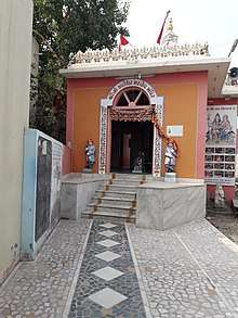
Kalya Mahadev's temple, outside the walls, is comparatively modern, with a dancing yogini as its goddess. Vankal Mata's temple, to the north-west of the town, is dedicated to a form of Bhavani. Bhareswar at some distance to the south-east has an old shrine and spire and a modern hall. To the west of the town is a temple of Dvarkanath, and close to it an unfinished one to Bahuchar Mata, with three shrines on as many sides of the entrance hall.[1] On the outskirts of the town is an ancient Hindu temple of Shiva, namely Bhadeshwar Mahadev Temple. There is Swaminarayan's temple located on the outskirts of the old fortress on the Eastern side of the town. Swaminarayan Sect is a relatively modern sect in Hinduism established by Ramanand swami The Guru of God Swaminarayan in the 19th century. It is believed that the god Swaminarayan visited Anjar during his lifetime, and a temple was constructed at the place where he stayed.
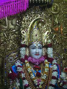
Trimandir: An idol of Shree Simandhar Swami is in the exact middle of the Trimandir. On the right side of the temple is Krishna Bhagwan while on the left is Shiv Bhagwan. Padmanabh Prabhu, Sai Baba, Ashapura Maa, Tirupati Balaji, Shree Nathji, Dada Bhagwan and other deities also reside within the temple.[12]
Jesal Toral Shrines
To east of Ajepal's monastery, is a small tiled shed with tombs of Muslim pattern sacred to Jesar or Jesal, a Jadeja, and Turi or Toral, a Kathi. The temple is locally known as Jesal Toral ni Samadhi, which literally means 'the tomb of Jesal and Toral'. The shrine at Anjar is under the charge of the Ajepal monastery.[1]
- Legend of Jesal-Toral
In the middle of the fourteenth century Jesar, grandson of the Jam Lakha Jadeja, became an outlaw, laid waste to fields and villages, killed the people, and carried off the cattle. At that time a Kathi woman, Turi or Toral by name, was famous for her devotion and her skill in making hymns, and still more famous for her beauty. She lived with an ascetic called Savasdhir, who did not regard her as his wife but as one who would bring him salvation. The fame of her beauty reached Jesar, who tried to carry her off by force but failed. Going back in the guise of an ascetic he was well received, and arranged to seize her at some midnight worship. His plans were found out, and, on his confessing, the sect whose rule was to grant the wish of every asker gave him Turi on condition that he became an ascetic. Jesar agreed, but soon tiring of the restraint, again tried to take Turi away by force. She foiled him, and in time changed him into a model ascetic. Settling at Anjar, Jesar died and Turi was buried alive close by his tomb. His descendants, the Jesar' Rajputs have, in each of the twelve villages, a shrine of Jesar and Turi.[1]
Buildings
MacMurdo's Bungalow is a state protected monument due to his wall paintings depicting scenes associated with Ram and Krishna.[13]
Cuisine
Anjar is famous for gher all over India even though the world gher procession only passed in the middle of the city. Anjar is also well known for its cuisine, specifically Dabeli. Anjar is also well known for the Kharek. Local people drink buttermilk known as Chhash. Other local items are Kutchi Pakwan, Kutchi Khaja, Pedas and farsan, etc. Pedha, Gulab Paak and Kharibhat are famous in the local area and Mumbai region.
Economy
The town has strong trade and social links with neighbouring Adipur, Bhuj, Gandhidham and Kandla. The GIDC (Gujarat Industrial Development Corporation) estate is situated here. Anjar is known for its ethnic clothes, handicrafts and metal-crafts. Swords and knives made in Anjar and nearby villages are exported outside India.
Culture
The people of Anjar come from many different backgrounds. Festivals like Holi, Sharad Purnima, Ram Navami, Navaratri, Hindola Mahotsava, Diwali, and Eid are celebrated within the town.
Education
The most famous schools in Anjar are Twinkle star English and Gujarati medium school, Shree Sahyog Saraswati Vidhya Mandir, Swami Vivekananda Vidhyalaya, Smt. K. G. Manek School, Sheth D. V. High School, Sheth Khatau Mavji Sethia H.S. School. There is also a different school for girls higher education- K. K. M. S. Girls' High School, among others. St. Elizabeth's School is an English language medium school. There are twenty primary schools handled by the Municipal Corporation of Anjar.
Notes
- 1 2 3 4 5 6 7 8 9 Gazetteer of the Bombay Presidency: Cutch, Palanpur, and Mahi Kantha. Printed at the Government Central Press. 1880. pp. 210–211.
- 1 2 3 4 5 6 EB (1878).
- 1 2 EB (1911).
- ↑ Another earthquake in Rann of Kutch took place on July 21, 1956 at a place called Anjar 80 miles south east of Allah Band and caused great damage to life and property.
- ↑
- ↑ he impact of the 2001 earthquake was particularly spectacular in the city of Anjar in certain well-defined areas of the city, and striking differences were observed in the damage distribution. The most damaged area was the old Anjar city (Gamtal area; see Figure 1), which was completely destroyed, while recently constructed buildings located across the street from the old city limits (mainly to the east and northeast) experienced only slight or no damage (AFPS 2001)
- ↑ Some cities were completely destroyed, like Anjar or Bachau. The city of Bhuj, located at around 20 km from the epicenter, suffered important losses.
- ↑ "Archived copy" (PDF). Archived from the original (PDF) on 14 December 2006. Retrieved 2010-11-04.
- ↑ Simpson, Edward (2006). "The Geography of Things That May Become Memories: The 2001 Earthquake in Kachchh-Gujarat and the Politics of Rehabilitation in the Prememorial Era". Annals of the Association of American Geographers. 96: 566–585. doi:10.1111/j.1467-8306.2006.00706.x.
- ↑ "Anjar Pin Code". citypincode.in. Retrieved 8 April 2014.
- ↑ Falling Rain Genomics, Inc - Anjar
- ↑ "Anjar Trimandir". Retrieved 2018-05-10.
- ↑ "અંજાર રાહ જુએ છે, ૨૧મી સદીના મેક મર્ડોની". Gujarat Samachar (in Gujarati). June 2016. Archived from the original on 19 September 2016. Retrieved 19 September 2016.
References

External links
Taluka of Anjar | ||
|---|---|---|
| Capital Town | Anjar | 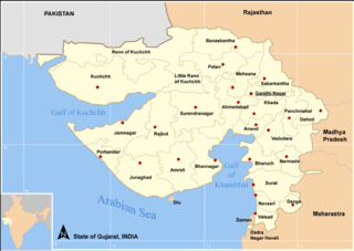 |
| Major cities | ||
| Villages of Anjar taluka | ||
| Topics | Sarpanch · Taluka Head · History · Notable people · Cities and Towns · Education institutes · National parks & Sanctuaries | |