Andelfingen District
| Andelfingen District Bezirk Andelfingen | |
|---|---|
| District | |
 | |
| Country |
|
| Canton |
|
| Capital | Andelfingen |
| Area | |
| • Total | 166.64 km2 (64.34 sq mi) |
| Population (31 December 2017) | |
| • Total | 31,235 |
| • Density | 190/km2 (490/sq mi) |
| Time zone | UTC+1 (CET) |
| • Summer (DST) | UTC+2 (CEST) |
| Municipalities | 24 |
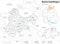
Coordinates: 47°37′N 8°40′E / 47.617°N 8.667°E Andelfingen District is one of the twelve districts of the German-speaking canton of Zurich, Switzerland.
It corresponds to the Zürcher Weinland, bounded by the Rhine to the north and west, by the canton of Thurgau to the east, by Winterthur to the south and by the Irchel to the southwest.
Municipalities
Andelfingen contains a total of twenty-four municipalities:
| Municipality | Population (31 December 2017)[1] |
Area, km² |
|---|---|---|
| Adlikon | 665 | 6.71 |
| Andelfingen | 2,208 | 6.65 |
| Benken | 858 | 5.67 |
| Berg am Irchel | 564 | 7.06 |
| Buch am Irchel | 971 | 10.26 |
| Dachsen | 1,936 | 2.69 |
| Dorf | 687 | 5.55 |
| Feuerthalen | 3,641 | 2.49 |
| Flaach | 1,390 | 10.16 |
| Flurlingen | 1,440 | 2.40 |
| Henggart | 2,268 | 3.01 |
| Humlikon | 486 | 3.70 |
| Kleinandelfingen | 2,076 | 10.36 |
| Laufen-Uhwiesen | 1,668 | 6.27 |
| Marthalen | 1,957 | 14.11 |
| Oberstammheim | 1,197 | 9.36 |
| Ossingen | 1,567 | 13.07 |
| Rheinau | 1,299 | 8.96 |
| Thalheim an der Thur | 929 | 6.44 |
| Trüllikon | 1,059 | 9.52 |
| Truttikon | 478 | 4.42 |
| Unterstammheim | 891 | 7.32 |
| Volken | 342 | 3.21 |
| Waltalingen | 658 | 7.25 |
| Total | 31,235 | 166.64 |
See also
References
- ↑ Swiss Federal Statistical Office - STAT-TAB, online database – Ständige und nichtständige Wohnbevölkerung nach institutionellen Gliederungen, Geburtsort und Staatsangehörigkeit (in German) accessed 17 September 2018
| Wikimedia Commons has media related to Zürcher Weinland. |
This article is issued from
Wikipedia.
The text is licensed under Creative Commons - Attribution - Sharealike.
Additional terms may apply for the media files.