Anaparti
| Anaparthi | |
|---|---|
| Town | |
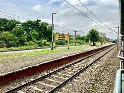 Anaparti railway station signboard | |
 Anaparthi Location in Andhra Pradesh, India | |
| Coordinates: 16°56′25.42″N 81°57′29.44″E / 16.9403944°N 81.9581778°ECoordinates: 16°56′25.42″N 81°57′29.44″E / 16.9403944°N 81.9581778°E | |
| Country | India |
| State | Andhra Pradesh |
| District | East Godavari |
| AreaSripuram Layout | |
| • Total | 3 km2 (1 sq mi) |
| Population (2011) | |
| • Total | 26,790 |
| • Density | 8,900/km2 (23,000/sq mi) |
| Languages | |
| • Official | Telugu |
| Time zone | UTC+5:30 (IST) |
| PIN | 533342 |
| Telephone code | 08857 |
| Vehicle registration | AP05 |
| Nearest city | Rajahmundry |
| Sex ratio | 1:1 ♂/♀ |
| Literacy | average% |
| Lok Sabha constituency | Rajahmundry |
| Vidhan Sabha constituency | Anaparthy |
Anaparthi (formerly Anapothavaram) is a town located in Anaparthi Tehsil/Block/Mandal, in East Godavari district of the Indian state of Andhra Pradesh. The town was named after King Anapotha Reddy of the Rajamahendravaram Dynasty.
Agriculture
Major crops cultivated in the area include tobacco, paddy, sugarcane and groundnuts.
Demographics
The local language is the Telugu language.
According to census figures, the total population of Anaparthi is 25,533, of which 12,856 are male and 12,677 are female.The total area of Anaparthi is 1807 hectares.
Geography
The closest cities to Anaparthi are Rajamundry and the coast town Kakinada.
Transport
The Anaparthi railway station is classified as a D–category station in the Vijayawada railway division of South Central Railway zone.[1] The station is situated between Samalkot and Rajahmundry. Anaparthi was the nearest railway station.
Mandapeta APSRTC Bus Station and Dwarapudi APSRTC Bus Station are near Anaparthi. APSRTC runs many buses from major cities to the town.
References
- ↑ "Vijayawada Division - A Profile" (PDF). South Central Railway. Retrieved 19 January 2016.
| Wikimedia Commons has media related to Anaparti. |