Na Mon District
| Na Mon นามน | |
|---|---|
| Amphoe | |
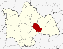 Amphoe location in Kalasin Province | |
| Coordinates: 16°34′31″N 103°47′12″E / 16.57528°N 103.78667°ECoordinates: 16°34′31″N 103°47′12″E / 16.57528°N 103.78667°E | |
| Country | Thailand |
| Province | Kalasin |
| Seat | Na Mon |
| Area | |
| • Total | 245.3 km2 (94.7 sq mi) |
| Population (2005) | |
| • Total | 35,234 |
| • Density | 132.6/km2 (343/sq mi) |
| Time zone | UTC+7 (ICT) |
| Postal code | 46230 |
| Geocode | 4602 |
Na Mon (Thai: นามน, pronounced [nāː mōn]) is a district (amphoe) in the eastern part of Kalasin Province, northeastern Thailand.
Geography
Neighboring districts are (from the northeast clockwise) Huai Phueng, Kuchinarai, Don Chan, Mueang Kalasin, and Somdet of Kalasin Province.
History
The minor district (king amphoe) Na Mon was created on 20 September 1973, when the three tambon Na Mon, Yot Kaeng, and Song Plueai were split off from Mueang Kalasin district.[1] It was upgraded to a full district on 1 January 1988.[2]
Administration
The district is divided into five sub-districts (tambon), which are further subdivided into 66 villages (muban). Na Mon is a township (thesaban tambon) which covers parts of the tambon Na Mon. There are a further five tambon administrative organizations (TAO).
| No. | Name | Thai name | Villages | Pop. | |
|---|---|---|---|---|---|
| 1. | Na Mon | นามน | 15 | 9,254 | |
| 2. | Yot Kaeng | ยอดแกง | 18 | 8,248 | |
| 3. | Song Plueai | สงเปลือย | 16 | 7,712 | |
| 4. | Lak Liam | หลักเหลี่ยม | 9 | 5,774 | |
| 5. | Nong Bua | หนองบัว | 8 | 4,246 |
References
- ↑ ประกาศกระทรวงมหาดไทย เรื่อง แบ่งท้องที่อำเภอเมืองกาฬสินธุ์ จังหวัดกาฬสินธุ์ ตั้งเป็นกิ่งอำเภอนามน (PDF). Royal Gazette (in Thai). 90 (119 ง): 3118. 25 Sep 1973.
- ↑ พระราชกฤษฎีกาตั้งอำเภอนามน อำเภอพระยืน อำเภอหนองบัวระเหว อำเภอบ้านเหลื่อม อำเภอจะแนะ อำเภอหนองหงส์ อำเภอนาโพธิ์ อำเภอเกาะยาว อำเภอแกดำ อำเภอสระโบสถ์ อำเภอโนนคูณ อำเภอควนโดน อำเภอไชยวาน อำเภอหนองแสง และอำเภอตาลสุม พ.ศ. ๒๕๓๐ (PDF). Royal Gazette (in Thai). 104 (278 ก special): 33–37. 31 Dec 1987.
External links