Amol County
| Amol County شهرستان آمل | |
|---|---|
| County | |
   .jpg) 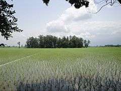 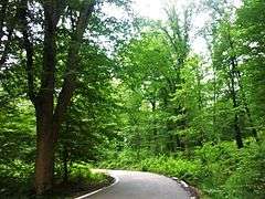 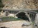 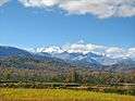 | |
 Counties of Mazandaran Province | |
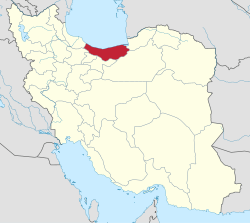 Location of Mazandaran Province in Iran | |
| Country |
|
| Province | Mazandaran |
| Established | 1946[1] |
| Government | |
| • Governor | Ahmad Monfared[2] |
| • MP | Ezzatollah Yousefian |
| Area | |
| • Total | 4,374 km2 (1,689 sq mi) |
| Population (2005)[3] | |
| • Total | 343,747 |
| • Density | 79/km2 (200/sq mi) |
| Time zone | UTC+3:30 (IRST) |
| • Summer (DST) | UTC+4:30 (IRDT) |
| Area code(s) | 0121 |
| Ethnic groups | Mazandarani |
| Language | Mazandarani, Persian |
| Website |
amol |
Amol County (Persian: شهرستان آمل) is a county in Mazandaran Province in Iran. The capital of the county is Amol. At the 2006 census, the county's population was 343,747, in 93,194 families.[4] The county is subdivided into three districts: the Central District, Larijan District, and Dabudasht District. The county has five cities: Amol, Rineh, Gazanak, Dabudasht & Amamzadeh Abdallah.
Amol's neighbour counties are Babol in the east, Mahmudabad in the north, Babolsar in the north-east, Noor in the west in Mazandaran province and Tehran province in the south.
Natural attractions
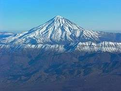
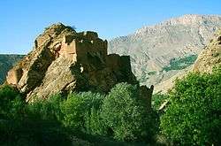
The county elevated landscape and valleys have dense forests. Its hills overlook the plains and stretch out to the high slopes of Damavand Mountains. The majestic valleys, rivers, springs, waterfalls, colorful vegetation, diversity of wildlife, thermal springs, summer quarters and rural settlements appeal to visitors. Mount Damavand, 5610 m, the highest point in the Middle East
Lar and Damavand Mountains
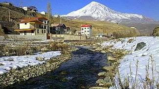
These mountains form the two branch ranges of the central Alborz Mountains, and are the highest sections of this range. To the north, after the Kahu (Sefid Ab) Pass, in the village of Garmabdar (district of Roodbar-e-Qasran), it sub-divides into two, the north western and south eastern ranges. In the south western sector are the peaks of Takht-e-khers and Se sang, extending towards the west, where the gigantic Damavand Peak is visible.
In the southeastern sector, after running along the plains of Lar, the famous peaks of Haft Saran are apparent, and to the south of these plains are the peaks of Mehr Chal, Atashkadeh, Siyah Chal and Maaz. In the south eastern direction it joins the Khansak and Shad Kooh Mountains.
Haraz River
The Haraz River's source is in the skirts of the Alborz Mountains in the region of Larijan. After flowing along the Haraz Road and Valley for about 100 km. it meanders in the midst of the city of Amol, from where it reaches the Caspian Sea. The fringes of this river are utilized as recreational areas as well as for fishing. The course that this river flows is beautiful and breath taking.
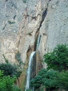
Waterfall
- Shahandasht: The Shahandasht Waterfall is the highest waterfall of Mazandaran Province. It is located in Shahandasht Village, 65 kilometers away from Amol, next to the Haraz Road from Amol to Tehran. It is 51 meters high flowing from the heart of Alborz Mountain. The waterfall is consisted of 3 waterfalls which make it 180 meters high. One can reach the waterfall by passing through the bridge of Vana Village and reaching the village of Shahandasht and walk towards the waterfall for 15 minutes on foot.
- Yakhi: Yakhi Waterfall with a height of 12 meters, is located in the vicinity of Doudkouh Mountain near the southern part of Damavand Peak in Mazandaran province.
This waterfall is spectacular in that it is completely frozen throughout the year, except the trickle of water flowing from melting glacier above it for a short period in summer. The said waterfall is one of its own in the world.
The other proposed Waterfall in county named, Ab Murad, Plas, Tara, Sang Darka, Qaleh Dokhtar, Peromed and Deryouk.
Springs and mineral water
- Ab Garm-e Larijan Thermal Springs: This thermal spring is near the Rineh village (Larijan). Its water is used in the treatment of joint disorders, skin diseases and infections. Damavand has some thermal springs (Abe Garm Larijan) with therapeutic qualities. These mineral hot springs are mainly located on the volcano's flanks and at the base, giving evidence of volcanic heat comparatively near the surface of the earth. While no historic eruptions have been recorded, hot springs at the base and on the flanks, and fumaroles and solfatara near the summit, indicate a hot or cooling magma body still present beneath the volcano, so that Damavand is a potentially active volcano.
In this village there are lots of hot baths. Of about 1,000 liters of water per minute Chshmە larijan SPA is removed. Its temperature is between 65 to 70 degrees Celsius. The unpleasant taste and odor of hydrogen sulfide and water color is clear. This is the source of magnesium and bicarbonate salts for skin disease, old wounds, rheumatism, respiratory tract diseases and neurological disorders is beneficial. Bath's famous monuments in the village of Shah Abbas Safavid period is related to The most important of these hot springs are located in Abe Garm Larijan in a village by the name Larijan in the district of Larijan in Lar Valley . The water from this spring is useful in the treatment of chronic wounds and skin diseases. Near these springs there are public baths with small pools for public use
- Ab Ask Thermal Springs: These springs are located in a village by the same name in the district of Larijan. Surrounding this spring are limestone deposits which through the passage of time turn into marble. The water from this spring is useful in the treatment of chronic wounds, and skin diseases.
- Amoloo Mineral Water Spring: The water from this spring can be used for drinking purposes, and is useful in treating gastro-intestinal disorders. The same can be used for skin diseases also. Being close to the Haraz River this vicinity has a beautiful landscape.
- Alamol: This waterfall flows from the northern slopes of the Damavand Mountains, and is more than 100 m. in height. The massive output of water from this waterfall forms a spray like mist in the air and brings about a wonderful sight.
- Esterabekoh
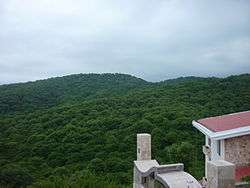
Forests and Jungle
This area with its elevated landscape and valleys has dense forests. Its tall hills overlook the plains and stretch out till the high slopes of the Damavand Mountains. The majestic and deep rocky valleys, rivers, numerous springs, elevated waterfalls, colorful vegetation, a variety of wild life, thermal springs, summer quarters, and rural settlements are some of the special factors which can prove attractive.
- Mirza Kuchak Khan Forest Park: The same is located 18 km. on the Amol - Tehran road, the Haraz River flowing on the eastern side of which.
- Alimastan: Alimestan Jungle is one of the most beautiful scenery in the spring and summer. This area is known as the Green Gold, dense fog, thick and green forests. The forest habitat plant “Alyma” grows in May which name is derived from the forest Alimestan. It has low temperature in the hot season. Numerous springs, diverse forest covers, plain and clear water, and beautiful horses are the indicators of the forest. Above all this, the Alimestan peak, about 2510 meters high, attracts many hikers in the winter and spring.
- Baliran There has thick forests and meadows. up until present Garm Rud 2 is the only well dated Upper Paleolithic settlement at the north of Iranian plateau. The land around the Baleyrān normal hill, but in the north it is flat.
- Halumsar
- Ziaru
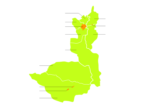
Administrative divisions
Larijan
Many historical and natural attractions in its place. This region has mountain villages, plains and meadows immense. Now due to the Damavand Haraz River originates best and highest quality trout is bred in the region of the Middle East. This is one of the most mythic Iran named Arash.
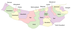
The shahrestan (county) of Amol is divided into 3 bakhshs (≈districts) and further into 8 dehestans (rural agglomerations).[5]
Cities and rural agglomerations
Population statistics
Amol county has a population of 360,409 according to the 2010 national census statistics. Distribution of the population is as the following table.[6]
| Subject | Total | Urban | Rural |
|---|---|---|---|
| Amol county total | 360,409 | 216,003 | 144,406 |
| - Central district total | 263,355 | 199,698 | 63,657 |
| - - Amol city | 213,332 | 213,332 | |
| - - Bala Khiaban Litkooh rural | 22,176 | 22,176 | |
| - - Paeen Khiaban Litkooh rural | 20,685 | 20,685 | |
| - - Chelav rural | 4,327 | 4,327 | |
| - Larijan district total | 8,721 | 1,575 | 7,146 |
| - - Rineh city | 1,213 | 1,213 | |
| - - Gazenak city | 362 | 362 | |
| - - Bala Larijan rural | 4,212 | 4,212 | |
| - - Paeen Larijan rural | 2,934 | 2,934 | |
| - Daboodast district total | 74,699 | 1,096 | 73,603 |
| - - Daboodasht city | 1,096 | 1,096 | |
| - - Daboo-ye Jonoobi rural | 37,796 | 37,796 | |
| - - Dasht-e Sar rural | 35,807 | 35,807 |
Tourism
In City and County:
- Damavand Mountain is a stratovolcano which is the highest peak in Iran and the Middle East. It has a special place in Persian mythology and folklore.
- Tomb of Mir Bozorg (Qavam al-Din Marashi Mausoleum)[7]
- Lar Dam
- Lar National Park
- Fire temple Amol
- Naser-Ol-Hagh Kabir Mausoleum (Hasan al-Utrush Tomb tower)[8]
- Sayyid Haydar Amoli (Seyyed Se Tan Tomb tower)[9]
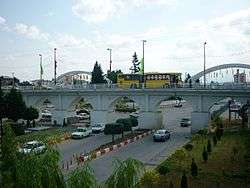
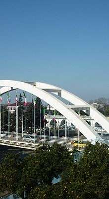
- Moalagh Bridge
- Davazdah Cheshmeh Bridge
- Waterfall Shahandasht
- Amol Bazaar[10]
- Museum of History
- Imamzadeh Ibrahim
- Malek Bahman Castle Shrine
- Shekl-e Shah (Relief Naser al-Din Shah Qajar)
- Jame Mosque
- Agha Abbas Mosque
- Yakhi Waterfall
- Dokhaharan lake
- Waterfall Deryouk
- Shah Abbasi Baths
- Fireplace (known as Shams Al-Rasol)
- The Sasanian Road
- Tower Khidr Nabi
- Tomb of Sultan Shahabuddin
- Village forest Blairan
- Village forest Alimastan
- Gol-e Zard Cave
- Ashraf Bath[11]
- Inn Kemboja
- House Manouchehri
- House Shafahi
- Heshtl Tower
- Mirza Muhammad Ali Mosque
- Kahrud Castle
- Sangi Bridge Polour
- Imam Hassan Askari Mosque
- Imamzadeh Qasem Shrine
- Imamzadeh Abdollah Shrine[12]
- Mohammad Taher Shrine[13]
- Ab ask Thermal Springs[14]
- Lake Sahon
- Haj Ali Kochak Mosque
- Ab Murad Waterfall
- Sang Darka Waterfall
- Dehkadeh Talaei Park
- Amoloo Mineral Water Spring
- Forest Park Mirza Kuchak Khan Haraz
- Forest Park Halumsar
- Castle Kahrud
- Larijan Thermal Spring
- Hosseinieh of Amol
- Gabri Tower
- Mir-Safi Baths
- Tomb Darvish Sheikh Ismail
- Robat Sangi Polur
- Prairie anemone of Polur
- Ziaru Jungle
- Haj Ali Arbab House
- Do Berar Peak
- Ancient Hill Qaleh Kesh
- Larijan Thermal Spring
- Kolakchal Mountain
- Ghoredagh Mountain
- Municipal House
- Tekyeh Firuz Kola
- Pol-e Mun Castle
- Saghanefar Hendoukola
- Saghanefar Zarrin Kola
- Tekyeh Oji Abad
- Karna Cave
 Lar National Park
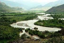 Haraz River
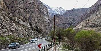 Haraz Road
- Paddy field in Amol
 Green pasture in Amol
Economy
Mineral water, meat, dairy, Wood and ingots the main production industrial are. Agriculture and Tourism are the basis economy Amol economic base is in its provincial products. Agriculture has always been a major part of the economy in and around Amol. Amol is the economic center of Mazandaran province, with Agriculture and Tourism being the base of the Amoli economy. Rice, grain, fruits, cotton, tea, sugarcane, and silk are produced in the lowland. Mineral water, meat, dairy, wood and ingots are the main manufacturing industry.[15]
References
- ↑ Amol county governship web site
- ↑ Shomal News
- ↑ "Census of the Islamic Republic of Iran, 1385 (2006)". Islamic Republic of Iran. Archived from the original (Excel) on 2011-11-11.
- ↑ "Census of the Islamic Republic of Iran, 1385 (2006)". Islamic Republic of Iran. Archived from the original (Excel) on 2011-11-11.
- ↑ http://www.ncc.org.ir
- ↑ Web page of the 2006 national census Archived 2007-06-01 at the Wayback Machine.
- ↑ "Mir-Buzurg Tomb". Retrieved September 4, 2006.
- ↑ "Big naser Tomb tower". Retrieved September 4, 2006.
- ↑ "Tomb tower Mir Haydar". Retrieved September 4, 2006.
- ↑
- ↑ In itto Ab
- ↑ In itto IAS
- ↑ "Shrine Taher". Retrieved September 4, 2006.
- ↑ In itto Ats
- ↑ Iranian Political Geography
- اطلس گیتاشناسی استانهای ایران [Atlas Gitashenasi Ostanhai Iran] (Gitashenasi Province Atlas of Iran)
- Damavand Mountaineering Guide
- Summit Post: Damavand
See also

| Capital | |||||||||||||||||||||||||||||||||||||||||
|---|---|---|---|---|---|---|---|---|---|---|---|---|---|---|---|---|---|---|---|---|---|---|---|---|---|---|---|---|---|---|---|---|---|---|---|---|---|---|---|---|---|
| Counties and cities |
| ||||||||||||||||||||||||||||||||||||||||
| Sights |
| ||||||||||||||||||||||||||||||||||||||||
| populated places | |||||||||||||||||||||||||||||||||||||||||