Amendolea
Coordinates: 37°56′N 15°53′E / 37.933°N 15.883°E
| Amendolea | |
|---|---|
 | |
| Country | Italy |
| Physical characteristics | |
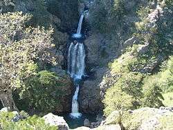
| Main source |
Aspromonte 1,805 m (5,922 ft) |
| River mouth | Ionian Sea |
| Length | 68.75 km (42.72 mi) |
| Basin features | |
| Basin size | 150.40 km2 (58.07 sq mi) |
The Amendolea (Greek Αμεντολέα Ποταμός from Greek αμυγδαλέα (=αμυγδαλιά)) is a river in the province of Reggio Calabria in the Calabria region of southern Italy.[1] Its source is near Montalto in Aspromonte National Park. The river flows south past Roghudi and Condofuri and empties into the Ionian sea west of Bova Marina.
References
This article is issued from
Wikipedia.
The text is licensed under Creative Commons - Attribution - Sharealike.
Additional terms may apply for the media files.