California State Route 130
| ||||
|---|---|---|---|---|
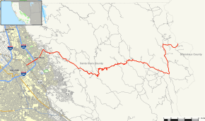 Map of Santa Clara County in western California with SR 130 highlighted in red | ||||
| Route information | ||||
| Defined by Streets and Highways Code § 430 | ||||
| Maintained by Caltrans | ||||
| Length | 22.503 mi[1] (36.215 km) | |||
| Major junctions | ||||
| West end |
| |||
|
| ||||
| East end | Stanislaus County Line | |||
| Location | ||||
| Counties | Santa Clara | |||
| Highway system | ||||
| ||||

State Route 130 (SR 130) is a state highway in the U.S. state of California in Santa Clara County. The route runs between San Jose and Patterson, passing Mount Hamilton on the way. Much of its length goes through the Diablo Range as Mount Hamilton Road, where it is a narrow two-lane highway. The remainder of SR 130 is numbered along Alum Rock Avenue in San Jose.
Route description
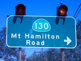
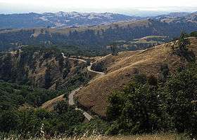
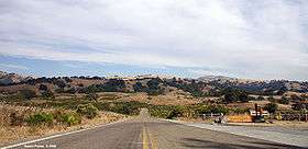
SR 130 begins in the west at U.S. Route 101 just east of Downtown San Jose and runs along the 4-6 lane Alum Rock Ave. It continues over a junction with Interstate 680 through San Jose's Alum Rock neighborhood. The road narrows as it begins to run into the foothills from four to six lanes down to two. Where Alum Rock Ave and Mt Hamilton Rd meet, SR 130 heads east up into the mountains along Mt Hamilton Rd, offering vistas of San Jose and the Santa Clara Valley, and traveling through some of the last remaining ranch and naturally wild land in Santa Clara County as well as Joseph D. Grant County Park. As SR 130 approaches the base of Mount Hamilton itself, the road narrows further and is barely capable of supporting two cars abreast. The narrow road begins a series of tight switchbacks that culminate on the summit of Mount Hamilton at the Lick Observatory. The observatory also serves as the existing route's eastern terminus at around 4,200 ft. (1,280 m) elevation. When snow falls on the higher elevations of the road, it is closed until crews can clear the snow and black ice. There is a small community in this area.
Though SR 130 is only signed up to this point, the road continues as San Antonio Valley Road. San Antonio Valley Rd eventually leads to Patterson, but there is also a turnoff toward Livermore. It consists of one to two lanes, and may be considered a part of SR 130 in the future. To the west, after the continuation of SR 130 Alum Rock Rd continues as Santa Clara Street, after which it becomes SR 82, continuing north to San Francisco. There are currently no plans to designate Santa Clara St between US Route 101 and SR 82 as SR 130.
A portion of SR 130 in San Jose is part of the National Highway System,[2] a network of highways that are considered essential to the country's economy, defense, and mobility by the Federal Highway Administration.[3]
History
SR 130 did not exist as a state highway before 1964; however, the roads it travels had existed since Lick Observatory was built. Legislatively, SR 130 continues for 30 additional miles (48 km) east of Lick Observatory to State Route 33 in Patterson, California through the San Antonio Valley. It is not signed officially as such and is not commonly recognized as existing beyond Lick Observatory. Both locals and most map makers do not acknowledge SR 130 existing east of the summit. In addition, east of Lick Observatory the road is maintained by the county rather than the state; the eastern portion still remains technically unbuilt.
Recently, signs have been erected with "San Antonio Road" with a small "CA-130 East" symbol in the upper right hand corner.
Future
Money had been set aside by the state to study the feasibility of turning part of SR 130's legislative route from San Antonio Valley Road east to Interstate 5 into a freeway. This was intended to facilitate traffic between the Santa Clara Valley and the Central Valley; the former is experiencing population growth and real estate development. The project's main proponent was former United States Representative Richard Pombo, who was the House Resources Committee chair when in Congress and himself a member of a family with extensive Central Valley property holdings near the proposed freeway's path.[4]
The proposed freeway's path west of San Antonio Valley Road would have bypassed Mount Hamilton either to the north toward State Route 237 or to the south toward San Jose's Evergreen district. The feasibility of the project came into question, however, as constructing a freeway over the Diablo Range near three of its highest peaks (Mount Hamilton included) would have been very difficult. The project also faced stiff opposition from taxpayers, environmentalists, residents of the area looking to preserve their area's local charm, and the Lick Observatory. (A freeway through the mountains near the observatory would render it useless by light pollution.) The freeway plan was quietly abandoned after Congressman Pombo failed in his reelection bid in 2006.
Major intersections
Except where prefixed with a letter, postmiles were measured on the road as it was in 1964, based on the alignment that existed at the time, and do not necessarily reflect current mileage. R reflects a realignment in the route since then, M indicates a second realignment, L refers an overlap due to a correction or change, and T indicates postmiles classified as temporary (for a full list of prefixes, see the list of postmile definitions).[1] Segments that remain unconstructed or have been relinquished to local control may be omitted. The entire route is in Santa Clara County.
| Location | Postmile [1][5][6] | Destinations | Notes | ||
|---|---|---|---|---|---|
| San Jose | 0.00 | Santa Clara Street | Continuation beyond US 101 | ||
| 0.00 | Interchange; west end of SR 130 | ||||
| 1.35 | Interchange | ||||
| | 11.23 | Quimby Road | |||
| | 22.50 | Mount Hamilton | East end of SR 130 | ||
| 1.000 mi = 1.609 km; 1.000 km = 0.621 mi | |||||
See also

References
- 1 2 3 California Department of Transportation. "State Truck Route List". Sacramento: California Department of Transportation. Archived from the original (XLS file) on June 30, 2015. Retrieved June 30, 2015.
- ↑ Federal Highway Administration (March 25, 2015). National Highway System: San Jose, CA (PDF) (Map). Scale not given. Washington, DC: Federal Highway Administration. Retrieved September 29, 2017.
- ↑ Natzke, Stefan; Neathery, Mike & Adderly, Kevin (June 20, 2012). "What is the National Highway System?". National Highway System. Washington, DC: Federal Highway Administration. Retrieved July 1, 2012.
- ↑ Gammon, Robert (2005-08-24). "Welcome to Pombo Country: Congressman Richard Pombo always sides with property owners. Sometimes that includes his own family". East Bay Express. Oakland. Retrieved 2018-10-09.
- ↑ California Department of Transportation (July 2007). "Log of Bridges on State Highways". Sacramento: California Department of Transportation.
- ↑ California Department of Transportation, All Traffic Volumes on CSHS Archived July 21, 2011, at the Wayback Machine., 2006
External links
Route map:
| Wikimedia Commons has media related to California State Route 130. |