Altenau, Lower Saxony
| Altenau | ||
|---|---|---|
| Stadtteil of Clausthal-Zellerfeld | ||
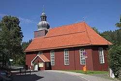 Saint Nicholas Church | ||
| ||
 Altenau | ||
| Coordinates: 51°48′10″N 10°26′44″E / 51.80278°N 10.44556°ECoordinates: 51°48′10″N 10°26′44″E / 51.80278°N 10.44556°E | ||
| Country | Germany | |
| State | Lower Saxony | |
| District | Goslar | |
| Town | Clausthal-Zellerfeld | |
| Area | ||
| • Total | 4.66 km2 (1.80 sq mi) | |
| Elevation | 460 m (1,510 ft) | |
| Population (2013-12-31) | ||
| • Total | 1,643 | |
| • Density | 350/km2 (910/sq mi) | |
| Time zone | CET/CEST (UTC+1/+2) | |
| Postal codes | 38707 | |
| Dialling codes | 05328 | |
| Vehicle registration | GS | |
| Website | www.altenau.de | |

Altenau ([ˈʔaltənaʊ] (![]()
It is situated in the middle of the Harz mountains, between Clausthal-Zellerfeld and the Brocken. It was part of the former Samtgemeinde ("collective municipality") Oberharz.
Geography
Districts
- Altenau
- Torfhaus
History
Demographics
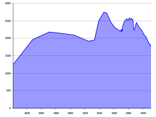
Population statistics
|
|
|
|
Sights
Politics
Town council
2006 local elections:
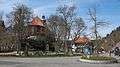 Town center
 Saint Oliver Church
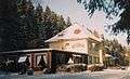 Former railway station
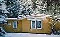 Side building, former railway station
References
External links
| Wikimedia Commons has media related to Altenau. |
- Samtgemeinde Oberharz (in German)
- Altenau at Curlie (based on DMOZ)
| Authority control |
|---|
This article is issued from
Wikipedia.
The text is licensed under Creative Commons - Attribution - Sharealike.
Additional terms may apply for the media files.