Alpgundkopf
| Alpgundkopf | |
|---|---|
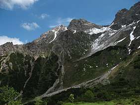 The Alpgundkopf from the Warmatsgundbach valley | |
| Highest point | |
| Elevation | 2,177 m above sea level (7,142 ft) |
| Prominence | 172 m ↓ Roßgundscharte |
| Isolation | 1.4 km → Saubuckelkopf |
| Coordinates | 47°19′19″N 10°14′14″E / 47.32194°N 10.23722°ECoordinates: 47°19′19″N 10°14′14″E / 47.32194°N 10.23722°E |
| Geography | |
| Parent range | Southeastern Walsertal Mountains, Allgäu Alps |
| Climbing | |
| First ascent | by locals |

The Alpgundkopf is a mountain, 2,177 m high, in the Allgäu Alps. It lies in the Schafalpenköpfe group, northeast of the Roßgundkopf, from which it is separated by the Alpgundscharte col. To the southeast, 383 metres away, lies the lower Alpkopf and, 1,035 metres away, the small lake of Guggersee.
Ascent
There are no waymarked paths up the Alpgundkopf. The normal approach is a trackless route from the notch of Alpgundscharte that requires sure-footedness and mountain experience. All other ascents are not recommended due to the brittle nature of the rock.
Photographs
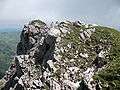 Summit block
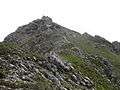 Southwest Arête
Literature
- Thaddäus Steiner: Allgäuer Bergnamen, Lindenberg, Kunstverlag Josef Fink, 2007, ISBN 978-3-89870-389-5
- Thaddäus Steiner: Die Flurnamen der Gemeinde Oberstdorf im Allgäu, München, Selbstverlag des Verbandes für Flurnamenforschung in Bayern, 1972
- Zettler/Groth: Alpenvereinsführer Allgäuer Alpen. Munich, Bergverlag Rudolf Rother, 1984. ISBN 3-7633-1111-4
External links
| Wikimedia Commons has media related to Alpgundkopf. |
This article is issued from
Wikipedia.
The text is licensed under Creative Commons - Attribution - Sharealike.
Additional terms may apply for the media files.