Aitutaki Airport
| Aitutaki Airport | |||||||||||||||
|---|---|---|---|---|---|---|---|---|---|---|---|---|---|---|---|
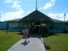 Entrance to Aitutaki Airport. Note the sign "Aitutaki International Airport", although there are no international flights. | |||||||||||||||
| Summary | |||||||||||||||
| Airport type | Domestic, public | ||||||||||||||
| Serves | Aitutaki | ||||||||||||||
| Location | Aitutaki, Cook Islands | ||||||||||||||
| Elevation AMSL | 14 ft / 4 m | ||||||||||||||
| Coordinates | 18°49′51″S 159°45′51″W / 18.83083°S 159.76417°W | ||||||||||||||
| Runways | |||||||||||||||
| |||||||||||||||
Aitutaki Airport is the airport for Aitutaki one of the Cook Islands (IATA: AIT, ICAO: NCAI). The airport was originally constructed by the United States and New Zealand militaries during World War II. The runway was upgraded in 2004.[1]
The terminal building at Aitutaki Airport is a roof with no or few windows. There is a small convenience stall where snacks and drinks can be purchased. Resort meet-and-greet stalls are also inside the terminal. Air Rarotonga serves Aitutaki with Saab 340A and Embraer Bandeirante aircraft.
Airlines and destinations
| Airlines | Destinations |
|---|---|
| Air Rarotonga | Atiu, Manihiki, Penrhyn Island, Pukapuka, Rarotonga |
References
- ↑ https://web.archive.org/web/20040904124321/http://www.cook-islands.gov.ck/view_release.php?release_id=312. Archived from the original on 4 September 2004. Retrieved 4 March 2007. Missing or empty
|title=(help)
External links


- Official website
This article is issued from
Wikipedia.
The text is licensed under Creative Commons - Attribution - Sharealike.
Additional terms may apply for the media files.