Aitkin, Minnesota
| Aitkin, Minnesota | |
|---|---|
| City | |
 | |
| Motto(s): "Historic Mississippi Riverboat Town"[1] | |
 Location of the city of Aitkin within Aitkin County, Minnesota | |
| Coordinates: 46°31′55″N 93°42′27″W / 46.53194°N 93.70750°W | |
| Country | United States |
| State | Minnesota |
| County | Aitkin |
| Incorporated | August 19, 1889[2] |
| Government | |
| • Mayor | Gary Tibbets |
| Area[3] | |
| • Total | 2.20 sq mi (5.70 km2) |
| • Land | 2.20 sq mi (5.70 km2) |
| • Water | 0 sq mi (0 km2) |
| Elevation | 1,211 ft (369 m) |
| Population (2010)[4] | |
| • Total | 2,165 |
| • Estimate (2016)[5] | 2,009 |
| • Density | 980/sq mi (380/km2) |
| Time zone | UTC-6 (Central (CST)) |
| • Summer (DST) | UTC-5 (CDT) |
| ZIP code | 56431 |
| Area code(s) | 218 |
| FIPS code | 27-00460[6] |
| GNIS feature ID | 0639235[7] |
| Website | www.ci.aitkin.mn.us |
Aitkin (/ˈeɪkɪn/ AY-kin) is a city in Aitkin County, Minnesota, United States. The population was 2,165 at the 2010 census.[8] It is the county seat of Aitkin County.[9]
History
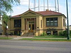
(Formerly Aitkin Carnegie Library)
Before the establishment of City of Aitkin, a transient community of Lexington was located at the mouth of the Ripple River.[10] However, maps from the 1860s erroneously depict the village of Ojibway (or Ogibeway), known today as Riverton, at the mouth of the Ripple River. Due to the importance of trade Lexington provided to the region, the Northern Pacific Railroad was then planned to pass near there. Aitkin was founded in 1870 when the Northern Pacific Railroad was extended to that point, replacing and then annexing Lexington.[11] The city and county were named for William Alexander Aitken, a partner of the American Fur Company and chief factor of the company's regional operations in the early 19th century.[12] Many industries had attracted people to the town. In the late 19th and early 20th century, a massive wave of immigration, mostly from present-day Ireland, Germany, and Scandinavian countries, moved into the Aitkin area to pursue the logging and riverboat industries. After the Great Depression and World War II, the logging industry has changed the town into a farming community, consisting mostly of cattle and poultry, which continued until the late 1970s to early 1980s. A creamery [13] and a turkey plant was one of the town's major economic and industrial contributors. Not many farms are currently in operation in Aitkin and many abandoned farms can be seen throughout the county. By the 1990s, Aitkin had changed into a community for retirement and tourism, especially with the lake areas, and that continues up to today. Health care, education, human services, and non-profit organizations are some of the major contributors to the modern-day Aitkin economy, along with the hospitality industry.
Aitkin throughout the years in various locations has been impacted by occasional flooding of the Mississippi River. Major notable floods had reached past 20 feet (6 m) such as the 1950 flood and nearly 19 feet (6 m), such as the summer flooding in 2012. Much damage has taken place in the town because of the floods, and the 2012 flood was one of the first floods that overflowed the lake areas, flooding the cabins, since it was caused by heavy rainfall instead of melting snow.
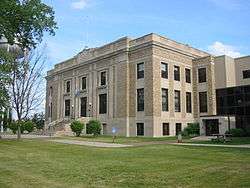
Five properties in Aitkin are listed on the National Register of Historic Places: the 1901 Patrick Casey House, the 1902 Potter/Casey Company Building, the 1911 Aitkin Carnegie Library, the 1916 Northern Pacific Depot, and the Aitkin County Courthouse and Jail (built in 1920 and 1915, respectively).[14]
Geography
According to the United States Census Bureau, the city has a total area of 2.20 square miles (5.70 km2), all of it land.[3]
The Mississippi River flows through at the northern edge of Aitkin. The Ripple River and Sissabagamah Creek both flow nearby.
Climate
| Climate data for Aitkin, Minnesota | |||||||||||||
|---|---|---|---|---|---|---|---|---|---|---|---|---|---|
| Month | Jan | Feb | Mar | Apr | May | Jun | Jul | Aug | Sep | Oct | Nov | Dec | Year |
| Average high °F (°C) | 18.7 (−7.4) |
25.3 (−3.7) |
37.8 (3.2) |
53.1 (11.7) |
66.9 (19.4) |
75.8 (24.3) |
79.5 (26.4) |
77.5 (25.3) |
67.7 (19.8) |
56.2 (13.4) |
37.9 (3.3) |
23.2 (−4.9) |
51.6 (10.9) |
| Average low °F (°C) | −2.9 (−19.4) |
2.5 (−16.4) |
15.7 (−9.1) |
29.9 (−1.2) |
40.9 (4.9) |
50.9 (10.5) |
55.8 (13.2) |
53.4 (11.9) |
44.8 (7.1) |
34.5 (1.4) |
21.0 (−6.1) |
5.4 (−14.8) |
29.3 (−1.5) |
| Average precipitation inches (mm) | 0.9 (23) |
0.7 (18) |
1.5 (38) |
2.4 (61) |
3.3 (84) |
4.3 (109) |
4.4 (112) |
3.9 (99) |
2.8 (71) |
2.4 (61) |
1.5 (38) |
0.8 (20) |
28.9 (734) |
| Source: Weatherbase[15] | |||||||||||||
Demographics
| Historical population | |||
|---|---|---|---|
| Census | Pop. | %± | |
| 1880 | 136 | — | |
| 1890 | 737 | 441.9% | |
| 1900 | 1,719 | 133.2% | |
| 1910 | 1,638 | −4.7% | |
| 1920 | 1,490 | −9.0% | |
| 1930 | 1,545 | 3.7% | |
| 1940 | 2,063 | 33.5% | |
| 1950 | 2,079 | 0.8% | |
| 1960 | 1,829 | −12.0% | |
| 1970 | 1,553 | −15.1% | |
| 1980 | 1,770 | 14.0% | |
| 1990 | 1,698 | −4.1% | |
| 2000 | 1,984 | 16.8% | |
| 2010 | 2,165 | 9.1% | |
| Est. 2016 | 2,009 | [5] | −7.2% |
| U.S. Decennial Census | |||
2010 census
As of the census[4] of 2010, there were 2,165 people, 936 households, and 483 families residing in the city. The population density was 984.1 inhabitants per square mile (380.0/km2). There were 1,097 housing units at an average density of 498.6 per square mile (192.5/km2). The racial makeup of the city was 95.5% White, 0.8% African American, 1.5% Native American, 0.3% Asian, 0.1% from other races, and 1.6% from two or more races. Hispanic or Latino of any race were 1.2% of the population.
There were 936 households of which 27.2% had children under the age of 18 living with them, 33.8% were married couples living together, 13.5% had a female householder with no husband present, 4.4% had a male householder with no wife present, and 48.4% were non-families. 43.5% of all households were made up of individuals and 25.1% had someone living alone who was 65 years of age or older. The average household size was 2.08 and the average family size was 2.88.
The median age in the city was 44.3 years. 22.2% of residents were under the age of 18; 7.2% were between the ages of 18 and 24; 21.4% were from 25 to 44; 22% were from 45 to 64; and 27.1% were 65 years of age or older. The gender makeup of the city was 45.3% male and 54.7% female.
2000 census
As of the census[6] of 2000, there were 1,984 people, 892 households, and 434 families residing in the city. The population density was 1,150.3 people per square mile (445.4/km²). There were 969 housing units at an average density of 561.8 per square mile (217.5/km²). The racial makeup of the city was 97.33% White, 0.15% African American, 1.31% Native American, 0.25% Asian, 0.05% Pacific Islander, 0.35% from other races, and 0.55% from two or more races. Hispanic or Latino of any race were 0.76% of the population. 30.4% were of German, 16.6% Swedish, 12.3% Norwegian and 6.5% Irish ancestry according to Census 2000.
There were 892 households out of which 22.5% had children under the age of 18 living with them, 36.5% were married couples living together, 9.8% had a female householder with no husband present, and 51.3% were non-families. 46.5% of all households were made up of individuals and 30.2% had someone living alone who was 65 years of age or older. The average household size was 2.03 and the average family size was 2.90.
In the city, the population was spread out with 20.8% under the age of 18, 7.5% from 18 to 24, 21.6% from 25 to 44, 17.6% from 45 to 64, and 32.4% who were 65 years of age or older. The median age was 45 years. For every 100 females, there were 76.2 males. For every 100 females age 18 and over, there were 69.8 males.
The median income for a household in the city was $47,574, and the median income for a family was $58,071. Males had a median income of $50,577 versus $31,641 for females. The per capita income for the city was $26,471. About 7.1% of families and 9.2% of the population were below the poverty line, including 11.0% of those under age 18 and 20.9% of those age 65 or over.
Arts and culture
Annual cultural events
The city's annual festivals include:
- Riverboat Heritage Days - the first weekend in August.
- The Aitkin County Fair - annually at the middle of July since 2008.
- Moonlight Madness - around Labor Day weekend.
- County Road Classics Fly-In Drive In takes place on the last Sunday in June.
- World Famous Fish House Parade takes place on Black Friday, the day after Thanksgiving. This event was noted in a 2003 documentary which aired on the Home and Garden Channel in the United States.
Education
Aitkin Public Schools are part of the Aitkin Public School District. Aitkin High School educates students in grades seven through twelve in the Aitkin School District. Rippleside Elementary educates students grades preschool to sixth grade.[16]
Infrastructure
Transportation
The Aitkin Municipal Airport is located at the northeast side of the city of Aitkin.
Major highways
The following routes are located within the city of Aitkin.
.svg.png)


- Aitkin County Road 1
- Aitkin County Road 12
- Aitkin County Road 15
- Aitkin County Road 41
Notable people
- Sean Conley: winner of the 2001 Scripps National Spelling Bee
- Jonathan Edwards: Singer/Songwriter, best known for his hit Sunshine
- Francis Lee Jaques: American wildlife painter
- Jean Keene: known nationwide as the "Eagle Lady" of the Homer Spit
- Robert Kerlan: orthopedic surgeon known for his contributions to sports medicine
- Gordon W. McKay: Oregon businessman and politician
- Warren William: notable Broadway and film actor with a star on the Hollywood Walk of Fame
American film actress and singer Judy Garland performed at the opera house in Aitkin as a young child. A small display related to Garland can be found in the converted opera house, now The Butler Building, in downtown Aitkin.[17]
References
- ↑ "City of Aitkin Minnesota". City of Aitkin Minnesota. Retrieved October 16, 2012.
- ↑ "Guide to Aitkin Minnesota". www.lakesnwoods.com. Retrieved 20 August 2017.
- 1 2 "US Gazetteer files 2010". United States Census Bureau. Archived from the original on 2012-01-24. Retrieved 2012-11-13.
- 1 2 "American FactFinder". United States Census Bureau. Retrieved 2012-11-13.
- 1 2 "Population and Housing Unit Estimates". Retrieved June 9, 2017.
- 1 2 "American FactFinder". United States Census Bureau. Archived from the original on 2013-09-11. Retrieved 2008-01-31.
- ↑ "US Board on Geographic Names". United States Geological Survey. 2007-10-25. Retrieved 2008-01-31.
- ↑ "2010 Census Redistricting Data (Public Law 94-171) Summary File". American FactFinder. U.S. Census Bureau, 2010 Census. Archived from the original on 21 July 2011. Retrieved 23 April 2011.
- ↑ "Find a County". National Association of Counties. Archived from the original on 2011-05-31. Retrieved 2011-06-07.
- ↑ Mitchell, Samuel Augustus. Map of Minnesota and Dakota. Philadelphia: Charles Desilver. 1859.
- ↑ Upham, Warren (1920). Minnesota Geographic Names: Their Origin and Historic Significance. Minnesota Historical Society. p. 14.
- ↑ "Profile for Aitkin, Minnesota, MN". ePodunk. Retrieved October 16, 2012.
- ↑ Hakes, Boyd. Mutual Creamary History, Aitkin, MN. Aitkin Historical Society. circa 1980. Retrieved July 31, 2013. http://www.aitkincohs.org/docs/mutual_creamery_history.pdf
- ↑ "Minnesota National Register Properties Database". Minnesota Historical Society. 2009. Retrieved 2017-01-29.
- ↑ "Weatherbase: Historical Weather for Aitkin, Minnesota". Weatherbase. 2011. Retrieved on November 24, 2011.
- ↑ "Aitkin Public School District". Aitkin Public School District. Archived from the original on October 23, 2012. Retrieved October 16, 2012.
- ↑ "Opera House". Butler’s – Aitkin, MN. Archived from the original on May 31, 2013. Retrieved October 14, 2012.
External links
| Wikivoyage has a travel guide for Aitkin. |
| Wikimedia Commons has media related to Aitkin, Minnesota. |
- City website
- Aitkin Aviation
- Aitkin Photo Gallery
- Aitkin Public School District
- Aitkin's Opera House
- City-Data.com
- ePodunk: Profile for Aitkin, Minnesota
- The Beanery coffee shop in the Butler building's site
Municipalities and communities of Aitkin County, Minnesota, United States | ||
|---|---|---|
| Cities | 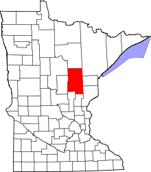 | |
| Townships |
| |
| Unorganized territories | ||
| Unincorporated communities | ||
| Indian reservations | ||
| Footnotes | ‡This populated place also has portions in an adjacent county or counties | |
Coordinates: 46°31′59″N 93°42′37″W / 46.53306°N 93.71028°W