Agios Nikolaos, Messenia
| Agios Nikolaos Άγιος Νικόλαος | |
|---|---|
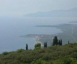 View of the coast from the hills above Agios Nikolaos | |
 Agios Nikolaos Location within the region  | |
| Coordinates: 36°49.45′N 22°16.85′E / 36.82417°N 22.28083°ECoordinates: 36°49.45′N 22°16.85′E / 36.82417°N 22.28083°E | |
| Country | Greece |
| Administrative region | Peloponnese |
| Regional unit | Messenia |
| Municipality | West Mani |
| Municipal unit | Lefktro |
| Lowest elevation | 0 m (0 ft) |
| Population (2011)[1] | |
| • Rural | 331 |
| Time zone | UTC+2 (EET) |
| • Summer (DST) | UTC+3 (EEST) |
| Postal code | 24024 |
| Area code(s) | 27210 |
| Vehicle registration | KM |
| Website | www.aghiosnikolaos-greece.com/en/ |
Agios Nikolaos (Greek: Άγιος Νικόλαος, Saint Nicholas) is a fishing village in the Mani Peninsula in southern Greece; it is popular with holidaymakers. The village, known to English-speaking tourists as "Ag Nik," lies about 30 kilometres (19 mi) south-east of Kalamata, on the eastern shore of the Messenian Gulf, and about 4 kilometres (2.5 mi) south of Stoupa, a larger tourist village. It is part of the municipal unit of West Mani in Messenia.
The population of Agios Nikolaos and similar fishing villages in this part of Greece fell rapidly in the decades after World War II through emigration, mainly to Australia, but since the road from Kalamata was built in the late 1960s the tourist business brought new prosperity to the area. Agios Nikolaos still has few tourist amenities, but the hills above the town offer Byzantine churches[2][3] and views of the Gulf and of the Taygetus mountains further inland.
It is still an active fishing harbour with a fish market most days. There are several Tavernas and Kafenons around the harbour. There is an emergency medical center, a pharmacy, a post office, and several small grocery stores.
Agios Nikolaos was formerly called SelinitsaEtymology[›] (meaning simply village, settlement). The name Selinitsa is still used by many locals. It was a centre of fighting during the Greek Civil War, being on the side of Government fighting the 'communists' who were mainly in the mountain villages. There are still three towers, built as machine gun emplacements scattered around the village; the largest about 20 metres or 66 feet high dominates the 'skyline' on the main road into the village. There are no documented ancient remains in the immediate area.
Notes
^ Etymology: Greek: Σελίνιτσα, from Slavic *Selьnica : selo »village, settlement«; compare also to current Slovene Selnica and Croatian/Serbian Seonica with the same meaning. Although Vasmer referred to another village of the same name about 4 kilometres (2.5 mi) north of Gytheio in Laconia – also located in the Mani – the same reasoning is applicable here.[4][5] Patrick Leigh Fermor in his 1958 book Mani: Travels in the Southern Peloponnese uses Selinitza.
References
- ↑ "Απογραφή Πληθυσμού - Κατοικιών 2011. ΜΟΝΙΜΟΣ Πληθυσμός" (in Greek). Hellenic Statistical Authority.
- ↑ Dean, Matthew (2006). Inside the Mani. Athens. ISBN 960-631-307-7. Retrieved 20 September 2010.
- ↑ Chapman, John (July 2008). "Mani: A Guide and History". Retrieved 20 September 2010.
- ↑ Vasmer, Max (1941). "III. Verzeichnis der slavischen geographischen Namen nach Landschaften geordnet: 21. Lakonien". Die Slaven in Griechenland (in German). Berlin: Verlag der Akademie der Wissenschaften. p. 172. Retrieved 21 September 2010.
- ↑ Malingoudis, Phaedon (1981). "Slavische Flurnamen aus der messinischen Mani". Studien zu Slavischen Ortsnamen Griechenlands. Abhandlungen der Geistes- und Sozialwissenschaftlichen Klasse (in German). 3. Mainz: Akademie der Wissenschaften und der Literatur. ISBN 3-515-03508-7.
External links