Ad Stoma
| Ad Stoma | |
|---|---|
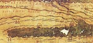 In Tabula Peutingeriana | |
 Location within Romania | |
| Attested by | Tabula Peutingeriana |
| Place in the Roman world | |
| Province | Moesia |
| Administrative unit | Moesia Inferior |
| Directly connected to |
|
| Location | |
| Coordinates | 44°53′02″N 28°50′07″E / 44.883947°N 28.835164°ECoordinates: 44°53′02″N 28°50′07″E / 44.883947°N 28.835164°E |
| Altitude | 93 m |
| Town | Enisala ? |
| County | Tulcea |
| Country |
|
| Site notes | |
| Condition | Ruined |
Ad Stoma was a fort in the Roman province of Moesia. As Tabula Peutingeriana shows it is situated between Histriopolis and Salsovia; 60 miles from Histriopolis and 24 miles from Salsovia.
See also
External links
Notes
This article is issued from
Wikipedia.
The text is licensed under Creative Commons - Attribution - Sharealike.
Additional terms may apply for the media files.