Aberfoyle railway station
| Aberfoyle | |
|---|---|
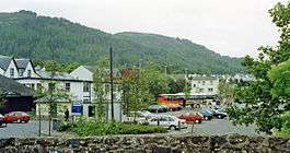 Location of the former station (1997) | |
| Location | |
| Place | Aberfoyle |
| Area | Stirling |
| Coordinates | 56°10′39″N 4°22′59″W / 56.17755°N 4.38303°WCoordinates: 56°10′39″N 4°22′59″W / 56.17755°N 4.38303°W |
| Operations | |
| Original company | Strathendrick and Aberfoyle Railway |
| Pre-grouping | North British Railway |
| Post-grouping | London and North Eastern Railway |
| Platforms | 1 |
| History | |
| 1 October 1882 | Station opens |
| 1 October 1951 | Station closes |
| 5 October 1959 | closed for freight |
| Disused railway stations in the United Kingdom | |
|
Closed railway stations in Britain A B C D–F G H–J K–L M–O P–R S T–V W–Z | |
|
| |
Aberfoyle railway station served the village of Aberfoyle in Scotland between 1882 and 1951.
History
Opened by the Strathendrick and Aberfoyle Railway, and absorbed into the North British Railway, it became part of the London and North Eastern Railway during the Grouping of 1923. Passing on to the Scottish Region of British Railways on nationalisation in 1948, it was then closed by British Railways.
| Preceding station | Historical railways | Following station | ||
|---|---|---|---|---|
| Gartmore | North British Railway Strathendrick and Aberfoyle Railway |
Terminus | ||
The site today
The old station is now demolished, replaced by a parking space.
References
- Butt, R. V. J. (1995). The Directory of Railway Stations: details every public and private passenger station, halt, platform and stopping place, past and present (1st ed.). Sparkford: Patrick Stephens Ltd. ISBN 978-1-85260-508-7. OCLC 60251199.
- Jowett, Alan (March 1989). Jowett's Railway Atlas of Great Britain and Ireland: From Pre-Grouping to the Present Day (1st ed.). Sparkford: Patrick Stephens Ltd. ISBN 978-1-85260-086-0. OCLC 22311137.
- Aberfoyle station on navigable O.S. map
- Railscot on the Strathendrick and Aberfoyle Railway
This article is issued from
Wikipedia.
The text is licensed under Creative Commons - Attribution - Sharealike.
Additional terms may apply for the media files.