2012 Aéro-Service Ilyushin Il-76 crash
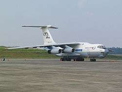
 An Ilyushin Il-76, similar to the aircraft involved | |
| Accident | |
|---|---|
| Date | 30 November 2012 |
| Summary | Clipped trees and crashed during final approach |
| Site | Maya-Maya Airport, Brazzaville, Republic of the Congo |
| Aircraft | |
| Aircraft type | Ilyushin Il-76T |
| Operator | Air Highnesses on behalf of Aéro-Service |
| Registration | EK-76300 |
| Flight origin | Pointe Noire Airport |
| Destination | Maya-Maya Airport |
| Passengers | 1 |
| Crew | 5 |
| Fatalities | 32 (6 + 26 on ground) |
| Injuries | 14 (on ground) |
| Survivors | 0 |
The 2012 Aéro-Services Ilyushin Il-76 crash occurred on 30 November 2012 in Brazzaville, Republic of the Congo. An Ilyushin Il-76T freighter, registration EK-76300, owned and operated by the Armenian cargo airline Air Highnesses on behalf of Congolese cargo airline Aéro-Service was flying from Pointe Noire Airport to Maya-Maya Airport in the Republic of the Congo. The aircraft was attempting to land on runway 5L in heavy rain, when it clipped high trees about 1000 meters from the runway threshold and disintegrated over 500 meters.[1] The aircraft caught fire and was destroyed, killing all five Armenian crew and an Armenian policeman present on board, as well as 26 local residents, injuring a further 14 as to require hospitalization. The aircraft was initially mistakenly attributed to Trans Air Congo.[2]
Investigation
On 28 February 2013, the Interstate Aviation Committee received the flight data recorder and the cockpit voice recorder for analysis on behalf of the Ministry of Transport of Congo. Both recorders show mechanical damage as a result of the impact. The IAC is working to reconstruct and download the data.[1]
References
- 1 2 Simon Hradecky (28 February 2013). "Crash: Aero Services IL76 at Brazzaville on Nov 30th 2012, impacted buildings short of runway". The Aviation Herald. Retrieved 2 August 2013.
- ↑ "Cargo plane crashes into houses in Congo-Brazzaville, killing 32". BNO News. 1 December 2012. Archived from the original on December 2014.