1996 Hammersmith Bridge bombing
| 1996 Hammersmith Bridge bomb | |
|---|---|
| Part of the Troubles | |
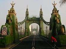 Entrance to Hammersmith Bridge from the south bank | |
| Location | Barnes, London, England |
| Date |
24 April 1996 22:54 (UTC) |
Attack type | Attempted bombing |
| Deaths | 0 |
Non-fatal injuries | 0 |
| Perpetrator | Provisional Irish Republican Army |
On 24 April 1996, the Provisional IRA planted two powerful bombs underneath Hammersmith Bridge in west London.[1] Although the detonators caused two small explosions, the bomb itself failed to explode. The bomb was located on the south side of the bridge and contained 30 lb of Semtex high explosives, which according to an explosives expert had the ability to blow up the entire bridge. It was the biggest high explosive device planted outside Northern Ireland, but just two months later was surpassed by the extra powerful Manchester bomb. The IRA gave two telephone warnings, the first at 22:22. Police located the device afterwards before it caused small explosions around 22:50. Scotland Yard said it was "meant to kill, cause injury and major structural damage to Hammersmith Bridge".[2][3]
The bombing attempt came on the day that Sinn Féin announced its participation in Northern Ireland elections in May on a "peace forum". It also occurred on the anniversary of the 1916 Easter Rising.[4]
Afterwards, the bridge was closed for three years for works. On 1 June 2000, the Real IRA, an IRA splinter group formed after the Good Friday Agreement, attempted to bomb the bridge again, but it did not cause significant damage.[5] The bridge was also previously targeted in 1939 under the S-Plan.
See also
References
- ↑ "IRA admit to failed London bombing". HeraldScotland.
- ↑ "London escapes IRA "spectacular" as 30lb of Semtex fail to detonate".
- ↑ "IRA bomb chaos in west London". 25 April 1996.
- ↑ "Bad Detonator Saves London From a Powerful IRA Bomb - The Tech". tech.mit.edu.
- ↑ "Hammersmith Bridge: tales of bombs, boat races and Bazalgette". 13 February 2016.
Coordinates: 51°29′16.42″N 0°13′50.57″W / 51.4878944°N 0.2307139°W