Łódź Fabryczna railway station
Łódź Fabryczna | |
|---|---|
| Premium | |
 | |
| Location |
Łódź, Poland |
| Owned by | Polskie Koleje Państwowe S.A. |
| Platforms | 4 |
| History | |
| Opened | 1866 |
| Previous names | Litzmannstadt Mitte |
| Location | |
 Łódź | |
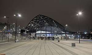
Łódź Fabryczna is the largest and most modern railway station in the city of Łódź, Poland. It was originally constructed at the initiative of industrialist Karl Wilhelm Scheibler in 1865. In the old Polish classification of stations it was placed under the B category.
The station is located in the centre of Łódź. Trains depart frequently via Koluszki to Warszawa Wschodnia, Kraków, Radom, Częstochowa, and Tomaszów Mazowiecki. It was closed on 16 October 2011 as a part of a major redevelopment project to build a new railway station and transport interchange[1] and reopened on 11 December 2016.[2]
History

Building of the Łódź – Koluszki railway line began on 1 September 1865 after authorization was obtained from Tsar Alexander II in July 1865. The new line linked Łódź with the Warsaw-Vienna Railway which was finished in 1848. Rails were laid simultaneously from Łódź and from Koluszki. By 18 November 1865 freight services began to use the line. Passenger services began the following June.
Construction of the railway was the beginning of the creation of the Łódź Circle Line.
Initially the station was further west on the site of the present Łódzki Dom Kultury (Łódź Cultural Centre). The track extended almost to ulica Sienkiewicza (Sienkiewicz Street). In 1868 a new station was built designed by the Warsaw-based architect Adolf Schimmelpfennig. The station was extended in 1930. In June 2012 the station was demolished to make way for the building of a new station below ground level.
Rebuilding
.JPG)
The modernization of the Łódź – Warsaw line includes building a new station below ground level, just north of the site of the former Łódź Fabryczna station. A ramp, leading to a new tunnel, begins immediately after Łódź Widzew station, and the tunnel itself starts near the site of Łódź Niciarniana station. Initially it was planned to change the name of the station to Łódź-Central or Central, but according to the latest plans, the station name will not change because it is too well associated with the current station.
The station was originally envisaged to service new high-speed trains that were to run on a new high-speed line, the 'Y' line, intended to link Warsaw via Łódź and Kalisz to Wrocław and Poznań. Due to the latest estimated cost of 10 billion Euro, the high-speed line was put on hold by Sławomir Nowak, the Ministry of Transport, Construction and Marine Economy at the time of the decision.
Moving Łódź Fabryczna below ground releases land for development near the city centre. A modern transport interchange is envisaged between PKP trains, MPK Łódź trams, buses and PKS coaches. The railway line is to be extended in a new cross-city twin-track tunnel to Łódź Kaliska railway station.
In November 2010 PKP PLK announced a list of five consortia that had been invited by the railway infrastructure manager to tender to build the underground station. Work was to be completed in 2014.[3]
In 2013 the estimated cost of the project was given as ranging from 1.7 to 1.9 billion PLN and the completion date was unknown.[4] Reconstruction works finished in December 2016 and the station has reopened.
References
- ↑ http://www.nlf-b2.pl/o-inwestycji?lang=en
- ↑ Czubiński, Roman (2016-12-11). "Tłumy na otwarciu nowej Łodzi Fabrycznej" [Crowds at the opening of Łódź Fabryczna]. Rynek Kolejowy (in Polish). Poland: Rynek Kolejowy. Retrieved 2017-01-13.
The first passengers just took advantage of the new underground station in the city center.
- ↑ "Łódź Fabryczna: pięć konsorcjów rywalizuje o kontrakt za 2 mld zł". Rynek Kolejowy. January 2011. p. 5. ISSN 1644-1958.
- ↑ "Dworzec Łódź Fabryczna: podziemne jezioro paraliżuje budowę". Dziennik Łódzki. 19 September 2013.
External links

Coordinates: 51°46′08″N 19°28′04″E / 51.76889°N 19.46778°E