Útila
| Utila | |
|---|---|
 Typical road near the Munchies Restaurant, a historic building | |
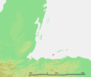
 Utila Location in Honduras | |
| Coordinates: 16°06′N 86°56′W / 16.100°N 86.933°W | |
| Country | Honduras |
| Department | Islas de la Bahía |
| Area | |
| • Total | 45 km2 (17 sq mi) |
| Elevation | 74 m (243 ft) |
| Population (2015) | |
| • Total | 4,160 |
| • Density | 92/km2 (240/sq mi) |
| Utila Island | |
|---|---|
 | |
| Elevation: | 74 m (243 ft) |
| Coordinates: | 16°06′N 86°56′W / 16.100°N 86.933°WCoordinates: 16°06′N 86°56′W / 16.100°N 86.933°W |
| Location: | Bay Islands, Honduras |
| Type: | Pyroclastic cones |
| Last eruption: | Unknown |
 | |
 Honduras | |
| Location |
Isla de Útila Bay Islands |
|---|---|
| Coordinates | 16°05′10.0″N 86°53′52.6″W / 16.086111°N 86.897944°W |
| Foundation | piles |
| Construction | concrete mast |
| Tower shape | square prism mast |
| Markings / pattern | red mast with horizontal white band |
| Height | 15 metres (49 ft) |
| Focal height | 15 metres (49 ft) |
| Light source | solar power |
| Range | 4 nautical miles (7.4 km; 4.6 mi) |
| Characteristic | F W |
| Admiralty number | J6003 |
| NGA number | 16448[1][2] |
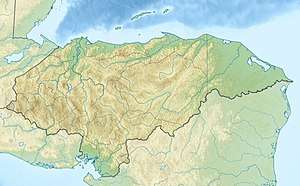
Utila (Isla de Utila) is the smallest of the Honduras' major Bay Islands, after Roatán and Guanaja, in a region that marks the south end of the Mesoamerican Barrier Reef System, the second-largest in the world.
The eastern end of the island is capped by a thin veneer of basaltic volcanic rocks, erupted from several pyroclastic cones including 74 m (243 ft) Pumpkin Hill which forms the highest point on the island. It has been documented in history since Columbus' fourth voyage, and currently enjoys growing tourism with emphasis on recreational diving and is known as one of the world's best dive locations.[3][4] The people of Utila are of African (Garifuna), English and Dutch descent.[5]
History
Archeological, historical and ethnographic evidence of the Bay Islands indicates that they were inhabited well before the Europeans arrived, as long ago as 600AD by a pre-Columbian culture known as the Paya. The Paya may have entered Central America in the great North to South America migration in 5,000 BC, although to the contrary, linguistic studies indicate that the Paya may have been descendants of South American tribes.[6]Christopher Columbus, on his fourth voyage to the new world, landed on the island of Guanaja on 30 July 1502, after encountering a small fleet of dugout canoes destined from the mainland to the Bay Islands. These vessels were filled with cotton cloth, maize, cacao, beans, copper goods and wooden swords with sharp flint edges, and on this meeting one dugout canoe carrying 25 men, women and children was captured.[7] On land, Columbus encountered a fairly large population of Paya whom he believed to be cannibals. In 1516, licensed slavers were sent to the Islands under the authority of Diego Velasquez and captured 300, killing others who put up resistance. The slaving vessel returned to Havana harbour, Santiago de Cuba, where it was taken over by the Paya who demanded repatriation. On hearing that the Paya had been repatriated, Velasquez commissioned two ships back which then captured 400 Paya on Utila and on one of the other islands, and during this raid 100 Paya were reported to have been killed. After their capture, this and future shipments of Paya slaves were forced to work in mines, farm sugar cane plantations and tend livestock on Santiago de Cuba,[8] and were also sent to work in the gold and silver mines of Mexico.
Later on, English, French, and Dutch pirates established settlements on the islands and raided the Spanish cargo vessels laden with gold and other treasures from the New World. The Welsh buccaneer Henry Morgan established his base at Port Royal on Roatán, about 30 kilometers from Utila, in the mid-17th century; at that time as many as 5,000 pirates were living on that island.
Colonization by the Spanish began in the early 16th century. Over the next century, the Spanish plundered the island for its slave trade and eliminated the island of its natives by the early 17th century. Britain, in its aggressive attempt to out-colonize the Spanish in the Caribbean, occupied the Bay Islands on and off between 1550 and 1700. During this time, the buccaneers found the vacated, mostly unprotected islands a haven for safe harbour and transport. Utila is rich in pirate lore, and even presently, scuba divers look for sunken treasure from Captain Morgan's lost booty from his raid on Panama in 1671.
The British were forced to give the Bay Islands to the Honduran government in the mid 19th century. It was at this time that the nearly uninhabited islands were being populated by its now Caymanian roots. They remain rich in Caymanian culture and dialect.
Utila has been a part of Honduras for approximately 150 years.[9][10] For nearly 200 years Spanish conquistadores and British pirates battled for control of these islands, ignoring the native people for the most part. During this period, the Islands were used for food and wood supplies, safe harbour, and slave trading. Remains of British forts and towns named after famous pirates remain as their legacy.
Making a significant impact on Utila's cultural base were the Black Caribs, who originated as the Callinagu in the Orinoco Delta in Brazil. Migrating north to the Lower Antilles the Callinagu subsequently exterminated the Arahuaco men, but kept and bred with their women creating a new ethic subgroup that became known as the Caliponan, or Yellow Caribs. In 1635 African slaves who had been shipwrecked by their own devices began to marry the Caliponan women, adopting their language and culture so as to assimilate locally and thwart their owners attempts to retrieve them. Thus the Garifuna society was born. On 12 April 1797, a total of 2,248 Garifunas were sent to Honduras and the Bay Islands in an attempt by the English to restrain the Garifuna from assisting the French in the English/French dispute over the islands of Martinica, and Santa Lucia. Scattered on the north coast of Honduras and in the Bay Islands, the Garifuna still populate much of the Bay Islands, maintaining their own cultural identity and language. On Roatan the Garifuna maintain a strong presence in the Sandy Bay community, on the western most side of East Harbor, a number of them having made the journey to Utila from Cayo Chachahuate, a small nearby island that is a bastion of the Bay Island's Garifuna.
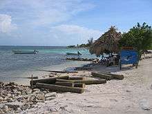
Tourism
With favourable diving conditions, the island increasingly attracts general tourists, along with more traditional international backpacker visitors. More than eighty diving sites are located around the island among its extensive reefs teeming with marine life, including the elusive whale shark.
Utila is also the home of the annual festival Sunjam. Sunjam is the largest electronic music event in Honduras, and one of the largest and most important in Central America. The date is fixed to the first Saturday of August every year. The event attracts world class international DJs as headliners and invites the best regional talent to perform.
Unique local cuisine includes white bread made with coconut milk, mango jam, conch meat, and crab.
The island is served by Útila Airport.
Image gallery
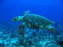 Hawksbill turtle at the "Black Hills" dive site
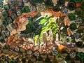 A glass grotto at the Unique Jade Seahorse Restaurant
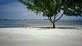 The ever calm waters at the public beach
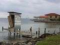 The outhouse over the water stands on the bay.
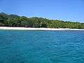 "Big Rock Beach"
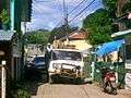 Typical traffic jam, there is only a handful of old pick-up trucks on the entire island
- The main beach
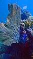 Coral surrounds the island.
See also
References
- ↑ Honduras The Lighthouse Directory. University of North Carolina at Chapel Hill. Retrieved 22 January 2017
- ↑ List of Lights, Pub. 110: Greenland, The East Coasts of North and South America (Excluding Continental U.S.A. Except the East Coast of Florida) and the West Indies (PDF). List of Lights. United States National Geospatial-Intelligence Agency. 2016.
- ↑ CNN, Anisha Shah, for. "Where to go in 2016: Top 16 up-and-coming destinations". CNN. Retrieved 2016-10-18.
- ↑ Intern, Talia Cuddeback Lifestyle; Post, The Huffington (2016-07-19). "15 Of The Best Dive Spots In The World". The Huffington Post. Retrieved 2016-10-18.
- ↑ "A Brief History of the Bay Islands by David Evans". www.aboututila.com. Retrieved 2016-10-18.
- ↑ Tomczyk, Thomas. "The Paya of Bay Islands". Voice Magazine, May 2011, p. 12-13.
- ↑ Tomczyk, Thomas. "The Paya of Bay Islands". Voice Magazine, May 2011, p. 13.
- ↑ Tomczyk, Thomas. "The Paya of Bay Islands". Voice Magazine, May 2011, p. 13-14.
- ↑ 1859 Treaty between Great Britain and the Government of Honduras English Translation ceding the Bay Islands and the British territory of the Mosquitia to the Republic of Honduras
- ↑ 1861 Honduras Decree English Translation in which the Bay-Islands and territory of the Mosquitia are declared to be under the Dominion and Sovereignty of the Republic of Honduras
External links
| Wikimedia Commons has media related to Útila. |
| Wikivoyage has a travel guide for Útila. |
Capital: Coxen Hole | |
| Municipalities | |