Île Royale
Locator map of Île Royale.
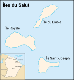
Île Royale (Royal Island) is the largest and westernmost island of the three Salvation's Islands, in the Atlantic Ocean off the coast of French Guiana. As the largest island, with an area of 28 hectares (69 acres), it was used as the centre for administration when the islands were used as a penal settlement. With an elevation of 66 metres (217 feet), the island is the highest of the group. It contains a museum and a hotel (l'Auberge des Îles du Salut) as well as an optical and infrared tracking site that supports space launches from the nearby Kourou facility.
| Wikimedia Commons has media related to Île Royale. |
External links
Coordinates: 5°17′14″N 52°35′20″W / 5.28722°N 52.58889°W
This article is issued from
Wikipedia.
The text is licensed under Creative Commons - Attribution - Sharealike.
Additional terms may apply for the media files.